
Indiana Ohio Kentucky Severe Storms Tonight Target Indianapolis Columbus Louisville With Damaging Winds Large Hail Tornado Risk and Record Breaking Heat Ahead of I 70
INDIANAPOLIS, INDIANA — A volatile weather setup is unfolding across the Ohio Valley today, combining near-record heat during the day with a strong line of severe storms expected tonight across Indiana, Ohio, and Kentucky.
Temperatures are surging well above normal ahead of an approaching cold front, setting the stage for potentially dangerous evening weather.
Near Record Heat Builds Across Indiana and Ohio
Daytime conditions are expected to feel more like early summer, with many locations south of I-70 reaching 80 degrees or higher.
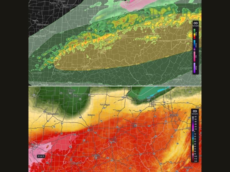
In Indianapolis, temperatures could climb to around 87 degrees, potentially breaking the city’s all-time March record of 85 degrees set in 1981. This unusual warmth is helping fuel atmospheric instability, increasing the likelihood of strong to severe storms later today.
Storms Develop After 8 PM and Move South
Storms are expected to begin forming around 8 PM, initially developing across northern areas before gradually moving from north to south through the evening.
The strongest storms are likely to track across central Indiana, western and central Ohio, and northern Kentucky, including cities like Indianapolis, Dayton, Columbus, and Louisville.
Damaging Winds and Large Hail Primary Threats
The main hazards associated with these storms include:
- Damaging wind gusts capable of causing power outages and tree damage
- Large hail, potentially severe in stronger storms
- Heavy rain and frequent lightning
Some storms may organize into stronger clusters, increasing the potential for widespread impacts.
Tornado Risk Also on the Table
In addition to wind and hail, a limited tornado threat exists, with the possibility of one or two isolated tornadoes developing. While not expected to be widespread, any storm that remains more organized could briefly rotate and produce a tornado.
Storm Line Already Taking Shape
Radar projections show a developing line of storms stretching from Indiana into Ohio and toward western Pennsylvania, indicating a well-defined system moving through the region.
This line is expected to strengthen as it taps into the warm, unstable air mass in place across the Ohio Valley.
What Residents Should Expect Tonight
Residents across Indiana, Ohio, and Kentucky should prepare for a busy weather evening, especially after sunset when storms intensify.
Key safety reminders include:
- Stay updated with weather alerts and warnings
- Avoid travel during peak storm activity if possible
- Have a safe place ready in case warnings are issued
A Rapid Weather Shift Ahead
Once the cold front passes, temperatures are expected to drop quickly, bringing a return to more seasonable conditions.
However, the immediate concern remains the combination of record-challenging heat and severe storms tonight, making this a high-impact weather day across the region. Forecasters continue to monitor storm development closely and urge residents to stay alert as conditions evolve.

I’ve lived in Naperville long enough to see how quickly our community changes — from new developments downtown to sudden shifts in our Midwest weather. Reporting on Naperville news and daily forecasts gives me the chance to keep neighbors informed about what really matters. My goal is simple: deliver clear, timely updates so you always know what’s happening in our city and what to expect from the skies above.