
Indiana Passes the Coldest Part of Winter as Historical Averages Show Temperatures Rising Steadily From Late Winter Into Early Summer
INDIANA — Weather data shared this week indicates that Indiana has officially passed the coldest part of winter, based on long-term average temperatures. From this point forward, historical trends show that temperatures gradually increase through spring and into early summer, even though additional winter weather may still occur.
The data emphasizes that while winter is not fully over, the overall temperature trajectory from here moves upward rather than colder.
What the Average Temperature Data Shows
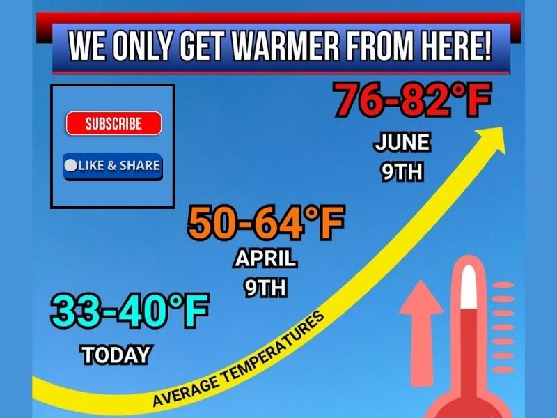
The graphic outlines how average temperatures change over time at key points of the year in Indiana:
- Today: Average highs range from 33°F to 40°F
- April 9: Average highs climb to 50°F to 64°F
- June 9: Average highs rise further to 76°F to 82°F
This progression illustrates a steady warming trend as Indiana transitions from late winter into spring and then early summer.
Why This Marks a Seasonal Turning Point
Climatologically, the coldest average temperatures in Indiana typically occur in late January and early February. Once past that window, daily averages tend to rise, even if short-term cold snaps still appear.
The data makes it clear that while below-average days and wintry precipitation remain possible, the odds increasingly favor warmer conditions as the season advances.
Winter Weather Still Possible Before Spring
The information shared also stresses that winter is not finished. Indiana may still experience:
- Late-season cold mornings
- Occasional snow or mixed precipitation
- Brief returns to below-normal temperatures
However, these events become less dominant as average temperatures continue to climb.
What This Means for Indiana Residents
As the seasonal shift progresses, residents can expect:
- Gradually milder daytime temperatures
- Increasingly frequent spring-like days
- Warmer air masses becoming more common by April
By early summer, average highs in the upper 70s to low 80s become typical, reflecting a complete transition away from winter conditions.
Looking Ahead
The data confirms that Indiana is entering the warming half of the year, even though winter weather hasn’t fully exited the stage. Each passing week brings higher average temperatures, setting the foundation for spring and summer ahead.
For continued weather trend analysis, seasonal outlooks, and climate-based reporting, follow updates on NapervilleLocal.com, where regional and national weather patterns are tracked with clarity and accuracy.

I’ve lived in Naperville long enough to see how quickly our community changes — from new developments downtown to sudden shifts in our Midwest weather. Reporting on Naperville news and daily forecasts gives me the chance to keep neighbors informed about what really matters. My goal is simple: deliver clear, timely updates so you always know what’s happening in our city and what to expect from the skies above.