
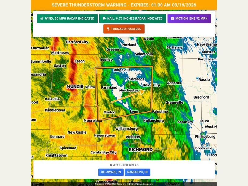
Indiana Severe Thunderstorm Warning Targets Delaware and Randolph Counties as 60 MPH Winds and Possible Tornado Threaten Muncie, Winchester and Union City
DELAWARE COUNTY, INDIANA — A powerful line of storms prompted a Severe Thunderstorm Warning for parts of eastern Indiana late Sunday night, with meteorologists warning that damaging winds, hail, and even a possible tornado could impact communities including Muncie, Ridgeville, Winchester, and Union City.
The warning covers Delaware County and Randolph County, where radar indicated a strong thunderstorm complex capable of producing wind gusts up to 60 mph and hail around three-quarters of an inch in diameter. Officials warned residents to remain alert as storms move rapidly through the region.
Storm Moving Quickly Across Eastern Indiana
Radar analysis shows the storm system moving east-northeast at approximately 52 mph, sweeping across towns from Muncie and Selma toward Farmland, Ridgeville, Saratoga, and Winchester.
This fast motion means conditions can deteriorate quickly.
Communities along the storm’s projected path include:
- Muncie
- Selma
- Farmland
- Ridgeville
- Saratoga
- Winchester
- Union City
- Lynn
- Modoc
The strongest portion of the storm appeared to be located near Winchester and Saratoga, where heavy rainfall bands and intense radar signatures suggested the potential for damaging wind bursts.
Damaging Winds and Hail the Primary Threats
Meteorologists warned that 60-mph wind gusts could knock down tree limbs, damage roofs, and cause scattered power outages.
The storm is also capable of producing hail up to 0.75 inches in diameter, which can damage vehicles, crops, and outdoor property.
In many severe thunderstorms across the Midwest, strong wind gusts often pose the greatest threat, particularly when fast-moving squall lines push through densely populated areas.
Residents in Muncie, Farmland, and surrounding communities were advised to stay indoors until the storm passes.
Tornado Cannot Be Ruled Out
While the warning is primarily for severe thunderstorms, forecasters indicated that a tornado is possible within the storm system.
Radar imagery suggested some rotation embedded in the storm as it tracked across Randolph County toward the Indiana-Ohio border.
Because of this risk, residents were urged to move to an interior room on the lowest floor of a sturdy building if severe weather approaches. Mobile homes and vehicles are particularly vulnerable during high-wind events and should be avoided as shelter.
Areas Near Ohio Border May See Strongest Storms
As the storm continues moving east-northeast, areas near Union City and communities close to the Indiana-Ohio state line may experience the strongest impacts.
The storm’s speed means it could cross Randolph County in a relatively short period of time before moving into western Ohio. Heavy rain bands around Winchester and Lynn also suggest localized downpours that may briefly reduce visibility for drivers overnight.
What Residents Should Do Now
Emergency managers recommend several safety steps during severe thunderstorm warnings:
- Move indoors immediately when warnings are issued
- Stay away from windows
- Secure outdoor items that could become airborne
- Monitor weather alerts on phones or local broadcasts
Travelers should also be cautious on roads near Muncie, Ridgeville, and Winchester, where strong winds and heavy rain could create dangerous driving conditions.
Storm Conditions Expected to Improve Overnight
The severe thunderstorm warning was scheduled to remain in effect until 1:00 AM EDT, with conditions expected to improve once the fast-moving storm system exits eastern Indiana. However, meteorologists will continue monitoring the storm as it moves toward Ohio.
Residents across Delaware and Randolph counties should remain alert for additional weather alerts in case new warnings are issued as the system evolves. Weather details in this report follow the formatting and reporting structure outlined for NapervilleLocal.com coverage standards .

I’ve lived in Naperville long enough to see how quickly our community changes — from new developments downtown to sudden shifts in our Midwest weather. Reporting on Naperville news and daily forecasts gives me the chance to keep neighbors informed about what really matters. My goal is simple: deliver clear, timely updates so you always know what’s happening in our city and what to expect from the skies above.