
Intense Heat Returning With Highs 88 to 98 Degrees Across Colorado Front Range and Eastern Plains With Lightning Gusty Winds and Stronger Storms Possible Tuesday
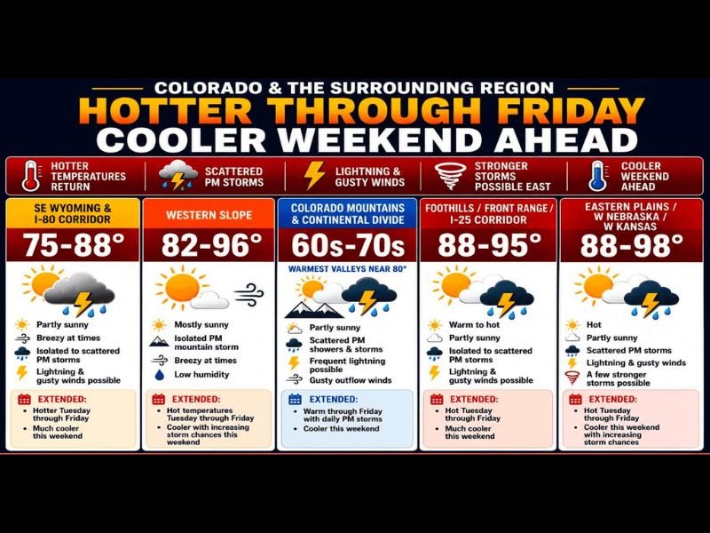
COLORADO AND SURROUNDING REGION — Gross heat returns across Colorado and the surrounding region Tuesday June 9th as temperatures climb back into the upper 80s to mid 90s across the Front Range and eastern plains, with the western slope reaching the low to mid 90s. A weak disturbance moving west to east will fire scattered showers and storms east of the Continental Divide through the afternoon and evening, with lightning and gusty winds the primary risks as storms race northeast.
Cooler and more comfortable conditions are on the way this weekend with 80s Saturday and 70s Sunday.
Front Range and Eastern Plains Face 88 to 98 Degree Heat With Storm Risk
The Foothills, Front Range, and I-25 corridor will see highs ranging from 88 to 95 degrees Tuesday under warm to hot and partly sunny conditions. Isolated to scattered afternoon storms are possible with lightning and gusty winds as the primary hazards for this zone.
The eastern plains into western Nebraska and western Kansas run the hottest at 88 to 98 degrees with a few stronger storms possible, scattered lightning, and gusty outflow winds through the afternoon and evening hours.
Microbursts and Gusty Winds Can Hit Without Warning in This Heat
Forecasters are emphasizing that in this kind of heat, gusty winds and microbursts can develop out of nowhere with little warning as storms bubble up quickly and collapse with dry air near the surface. Anyone near lakes, rivers, or reservoirs needs to stay particularly alert as these outflow wind events can create dangerous conditions on the water with virtually no lead time.
Lightning and gusty outflow winds remain the primary hazards east of the Continental Divide through Tuesday evening.
Cooler Pattern Arrives This Weekend With 80s Saturday and 70s Sunday
The extended heat through Friday gives way to a much more comfortable weekend pattern, with temperatures dropping into the 80s Saturday and the 70s Sunday along with increasing precipitation chances. Temperatures are expected to remain cooler through the first half of next week before gradually warming again.
Wednesday brings hot, dry, and breezy conditions with little to no rainfall across most zones. Stay with NapervilleLocal.com for the latest weather updates and local forecast coverage.

I’ve lived in Naperville long enough to see how quickly our community changes — from new developments downtown to sudden shifts in our Midwest weather. Reporting on Naperville news and daily forecasts gives me the chance to keep neighbors informed about what really matters. My goal is simple: deliver clear, timely updates so you always know what’s happening in our city and what to expect from the skies above.