
Iowa and Missouri Face Level 3 Severe Storm Threat Friday With Supercells Large Hail and Tornado Risk Expanding Toward Illinois and Wisconsin
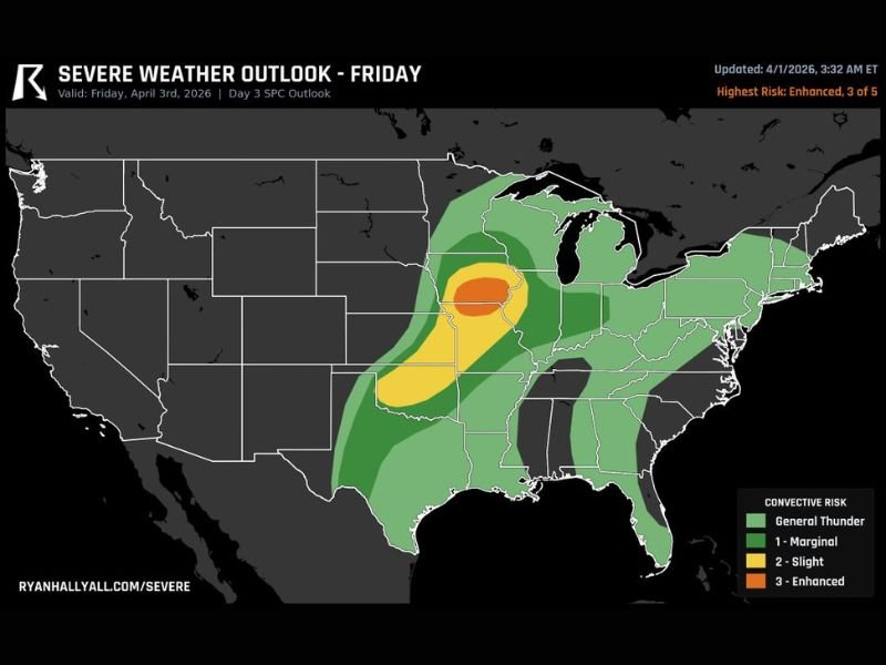
DES MOINES, IOWA — A dangerous round of severe weather is expected to develop Friday across parts of the Midwest, with Iowa and northern Missouri under a Level 3 enhanced risk, signaling the potential for significant storms including supercells, large hail, and tornadoes.
This setup is part of a multi-day severe weather pattern, with conditions continuing to reload across the region.
Enhanced Risk Zone Centers on Iowa and Northern Missouri
Forecast data highlights the highest threat area across:
- Central and eastern Iowa
- Northern Missouri
Cities in and near this enhanced risk zone include:
- Des Moines, Iowa
- Surrounding central Iowa communities
- Portions of northern Missouri extending toward the Iowa border
This Level 3 designation indicates a higher likelihood of organized severe storms, including long-lived supercells.
Supercells Capable of Large Hail and Tornadoes
The primary concern Friday centers on supercell development, which can produce multiple hazards.
Expected threats include:
- Very large hail, potentially exceeding severe criteria
- Damaging winds from stronger storm systems
- Tornado potential, especially with rotating storms
These storms could become intense quickly, particularly during peak heating hours.
Severe Risk Extends Into Surrounding States
While Iowa and northern Missouri face the greatest threat, a broader risk area stretches outward into surrounding states.
This includes parts of:
- Illinois
- Wisconsin
- Kansas
- Portions of the Midwest and central Plains
These regions remain under lower-tier risk levels but could still see severe storms depending on how the system evolves.
Multi-Day Severe Pattern Adds to Concern
Friday marks another day in an ongoing stretch of active weather, with three consecutive days of severe storm potential across parts of the country.
This repeated pattern can:
- Increase the chance of cumulative impacts
- Saturate ground conditions in some areas
- Keep residents on alert over multiple days
Timing and What to Expect
Although exact timing will vary, storms are expected to:
- Develop during the afternoon hours
- Intensify into the evening
- Potentially continue into the nighttime
Residents should be prepared for rapidly changing conditions throughout the day.
Residents Urged to Prepare Ahead of Severe Weather
With a higher-end risk in place, residents across Iowa and northern Missouri should take precautions ahead of Friday’s storms.
Recommended actions include:
- Identifying a safe shelter location
- Monitoring weather alerts throughout the day
- Preparing for potential hail and wind damage
Dangerous Weather Setup Heading Into Friday
The overall pattern points to a potentially dangerous severe weather day, particularly across Iowa and northern Missouri where the enhanced risk is centered.
Conditions will continue to be monitored as this severe weather event approaches. Stay with NapervilleLocal.com for continued updates and real-time severe weather coverage.

I’ve lived in Naperville long enough to see how quickly our community changes — from new developments downtown to sudden shifts in our Midwest weather. Reporting on Naperville news and daily forecasts gives me the chance to keep neighbors informed about what really matters. My goal is simple: deliver clear, timely updates so you always know what’s happening in our city and what to expect from the skies above.