
Kentucky and Southern Indiana Face Level 2 Severe Storm Risk February 19–20, 2026, With Damaging Wind, Hail and Isolated Tornado Potential
KENTUCKY AND SOUTHERN INDIANA — A developing storm system is setting the stage for a round of potentially strong to severe thunderstorms across the region on February 19 and 20, 2026, with forecasters highlighting a Level 2 “Slight Risk” across much of central and western Kentucky and nearby southern Indiana communities.
While this system is not expected to bring widespread high-end severe weather, the setup is organized enough that residents from Louisville to Lexington, Owensboro to Frankfort, and north into southern Indiana along the Ohio River should stay weather-aware as storms develop.
Where the Highest Risk Is Centered
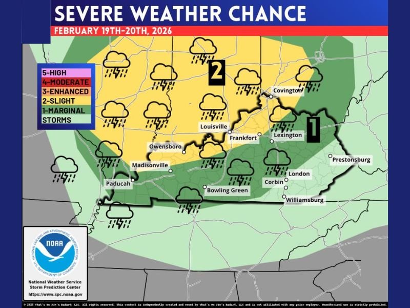
The latest outlook map places a Level 2 Slight Risk across central and western Kentucky, including cities such as Louisville, Owensboro, Frankfort, Madisonville, and Covington. Southern Indiana counties near the Ohio River are also included in this higher-end threat zone.
A Level 1 Marginal Risk extends farther east and southeast, including areas near Lexington, London, Bowling Green, Corbin, and Williamsburg.
A Level 2 designation means scattered severe storms are possible. Not everyone will see severe weather, but a few storms could become strong enough to cause localized damage.
Damaging Wind Is the Primary Concern
Forecasters indicate that strong straight-line winds are the most widespread threat with this setup. In the Slight Risk zone, storms could produce wind gusts of 60 mph or higher. That’s strong enough to knock down tree limbs, cause scattered power outages, and lead to minor structural damage in isolated spots.
Even in the Level 1 zone, isolated strong wind gusts remain possible. Coverage would be more limited there, but a single stronger cell could still create localized impacts.
Hail and Isolated Tornadoes Cannot Be Ruled Out
Hail is also part of the concern, especially in stronger rotating storms. Probability guidance suggests some areas could see hail of at least quarter size or larger, which is capable of denting vehicles and damaging roofs.
Tornado chances are lower than the wind threat but not zero. The probability shading indicates a low-end but meaningful tornado risk, particularly within the Slight Risk area.
In severe weather forecasting terms, even a 5 to 9 percent tornado probability within 25 miles of a point is something meteorologists take seriously. It doesn’t mean tornadoes are guaranteed — it means the atmospheric ingredients could support a few storms that try to spin.
Timing and What It Means
The outlook covers February 19–20, suggesting storms could develop during that window as a frontal system interacts with warmer, unstable air moving into the region.
A Level 2 designation does not mean widespread destruction is expected. It means:
- Severe storms are possible.
- Wind damage is the most likely hazard.
- Hail is possible.
- A brief, isolated tornado cannot be ruled out.
Residents should monitor updated forecasts as the system draws closer, since timing and placement can still shift.
Stay Weather Aware
This is not a panic situation, but it is a “pay attention” setup for Kentucky and southern Indiana. Make sure you have multiple ways to receive weather warnings, especially during the overnight hours. Secure outdoor items that could be blown around, and know where you would go if a warning is issued.
Storms may be scattered, meaning one town could see strong winds while another nearby community stays mostly quiet. We will continue monitoring this developing system and provide updates as new data becomes available. For continued weather coverage and regional updates, stay connected with NapervilleLocal.com.

Naperville is a community with stories that deserve to be told — both the serious ones about safety and justice, and the lighter ones that capture our culture and daily life. I focus on covering crime reports and court updates while also highlighting the traditions, events, and social trends that shape who we are. Through my reporting, I want to give readers a fuller picture of Naperville — the challenges we face and the character that keeps our city strong.