
Kentucky Braces for a Late-Week Cold Front Bringing Showers, Storms, Gusty Winds, and a Sharp Temperature Drop
KENTUCKY – After several days of gradually milder weather, a late-week cold front is expected to move into Kentucky, bringing a noticeable change that includes showers, storms, very gusty winds, and a drop to much colder temperatures, according to forecast signals shown in the latest weather data.
The shift is expected toward the end of the week, marking the first significant weather disruption after a relatively calm and warming stretch.
Milder Pattern Holds Before Late-Week Change
Forecast trends indicate that temperatures will continue trending milder through much of the upcoming week, with no major disruptions at first. Conditions remain relatively quiet until the cold front begins pushing toward the Commonwealth. This warming trend may give a false sense of stability, as the most impactful weather arrives later rather than earlier in the week.
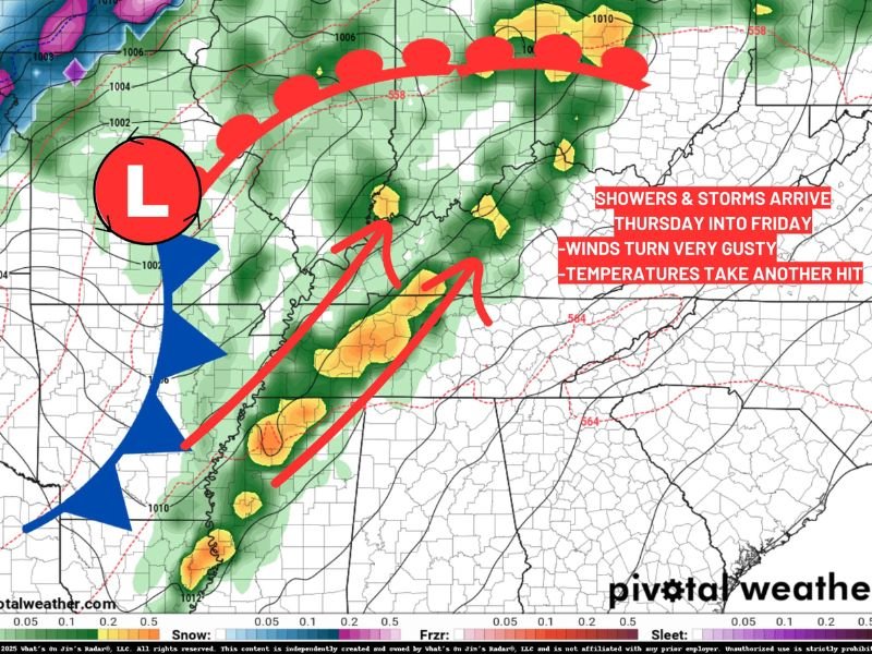
Cold Front Brings Showers and Storms
As the cold front advances into Kentucky, showers and thunderstorms are expected to develop, especially as the system strengthens. Weather graphics highlight a corridor of heavier precipitation accompanying the front, signaling a more active weather period than earlier in the week. Rainfall will be the primary concern, though the storms themselves may be brief but intense in spots.
Gusty Winds Arrive Ahead of the Front
One of the most notable impacts will be very gusty winds, which are expected to arrive before the cold front fully crosses the state. These winds could become strong enough to cause travel issues, especially for high-profile vehicles, and may lead to isolated power disruptions. The timing of the winds ahead of the main system makes this feature particularly important to monitor.
Temperatures Set to Drop Sharply
Once the front passes, temperatures are expected to fall from the milder levels to much colder conditions, reinforcing that winter is far from finished. This drop will mark a clear contrast from the warming trend earlier in the week. While no specific snowfall signal is shown in the data, the colder air behind the front signals a return to a more typical winter pattern.
What to Watch Going Forward
Residents across Kentucky should remain alert late in the week for changing conditions, strong winds, and rapidly falling temperatures. Even without winter precipitation, the combination of storms and wind makes this a system worth close attention. NapervilleLocal.com will continue monitoring this developing pattern and provide updates as timing and impacts become clearer.

I’ve lived in Naperville long enough to see how quickly our community changes — from new developments downtown to sudden shifts in our Midwest weather. Reporting on Naperville news and daily forecasts gives me the chance to keep neighbors informed about what really matters. My goal is simple: deliver clear, timely updates so you always know what’s happening in our city and what to expect from the skies above.