
Kentucky Could See Light, Slushy Snow Accumulation on Sunday as Weak System Moves Through on January 11, 2026
KENTUCKY — A weak snow-producing system could bring light snow accumulations across parts of Kentucky on Sunday, January 11, 2026, according to forecast data shown in the latest snow potential outlook. While totals appear minimal, the system is positioned well enough to create brief slushy coatings, especially in central and eastern portions of the state.
Forecasters describe this setup as a low-impact snowmaker, meaning widespread disruptions are not expected. However, some areas could still see measurable snowfall, particularly during periods of steadier precipitation.
What the Snow Map Shows Across Kentucky
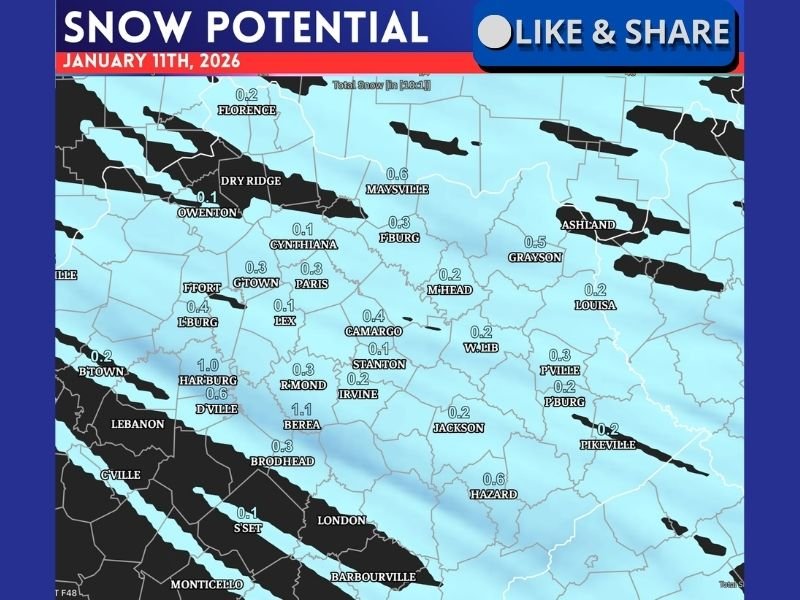
The snow potential map highlights light accumulation amounts across much of Kentucky, generally ranging from a dusting up to around 1 inch in a few localized spots.
Several communities shown on the map fall within the 0.2 to 0.6 inch range, while a small pocket near Berea shows potential totals slightly above 1 inch. Cities including Lexington, Richmond, Paris, Georgetown, Irvine, Stanton, Jackson, Hazard, and Pikeville are all depicted within light snow shading. The coverage suggests snow will not fall evenly, with narrow bands producing slightly higher totals where precipitation aligns best with colder air.
Why This Is Considered a Low-Impact Event
Despite the presence of snow on the map, forecasters caution that this system is not expected to be a major winter storm.
The snowfall is described as slushy, meaning surface temperatures may be marginally cold enough for snow to accumulate briefly before melting. Roads, especially treated main routes, are likely to remain mostly wet, though elevated surfaces and untreated roads could become slick for short periods. This type of system often produces visually noticeable snow without long-lasting impacts.
Timing and What to Watch On Sunday
The snow potential graphic is valid for Sunday, January 11, indicating that any snow would occur during a relatively short window.
Because this system is weak, small changes in temperature or precipitation intensity could significantly affect totals. If snowfall rates increase briefly, some areas could see quicker accumulation. If temperatures remain just a degree or two warmer, snowfall may struggle to stick at all. Forecasters also note that next week’s winter potential will be reviewed separately, suggesting additional systems may follow.
What Residents Should Keep in Mind
While this event is unlikely to cause major problems, residents should still remain aware of conditions, especially if traveling early Sunday morning or after sunset when surfaces cool more quickly. Light snow events like this can still create isolated slick spots, particularly on bridges, hills, and secondary roads.
NapervilleLocal.com will continue tracking winter weather trends nationwide and provide clear, data-driven updates as new information becomes available. Share this update with friends or family traveling through the region this weekend.

I’ve lived in Naperville long enough to see how quickly our community changes — from new developments downtown to sudden shifts in our Midwest weather. Reporting on Naperville news and daily forecasts gives me the chance to keep neighbors informed about what really matters. My goal is simple: deliver clear, timely updates so you always know what’s happening in our city and what to expect from the skies above.