
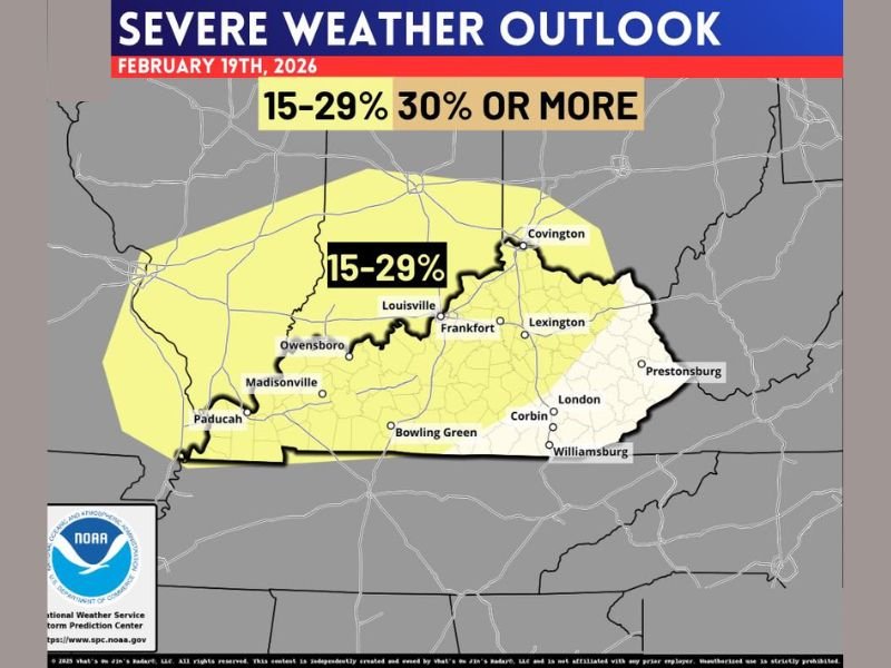
Kentucky Placed in Day 4 Severe Weather Outlook With 15–29% Storm Risk From Paducah to Louisville and Lexington on February 19
Louisville, Kentucky — The Storm Prediction Center has placed much of Kentucky under a Day 4 severe weather outlook for Thursday, February 19, 2026, signaling a notable early heads-up for potential strong storms later this week. The outlook highlights a 15–29% probability of severe storms within 25 miles of any given point, which meteorologists say is significant at this lead time.
The highlighted area covers a broad portion of the state, including Louisville, Lexington, Frankfort, Bowling Green, Owensboro, Madisonville, and Paducah. Northern communities near Covington are also included in the risk zone, while southeastern cities such as London, Corbin, Williamsburg, and Prestonsburg sit closer to the edge of the outlined area.
What the 15–29% Risk Means
A 15–29% risk does not mean severe weather is guaranteed. Instead, it reflects the probability of at least one severe thunderstorm occurring within 25 miles of any location inside the shaded area. For a Day 4 forecast, this level of probability indicates that atmospheric ingredients could align to support strong storms.
Forecasters emphasize that this is not a warning, but rather an early alert that the broader weather pattern is trending toward instability. As additional data becomes available over the next several days, timing and severity details will become clearer.
The outlook map shows most of central and western Kentucky squarely within the risk zone, with the higher probability area centered around Louisville and extending southwest toward Paducah.
Potential Hazards Later This Week
In February setups like this, meteorologists typically monitor for damaging wind gusts, heavy rainfall, and the possibility of a tornado risk, depending on how much instability and wind shear develop. Early indications suggest wind-driven storms may be the primary concern, though exact impacts will depend on storm timing and strength.
Western Kentucky cities such as Owensboro and Madisonville may see stronger storm potential if instability maximizes in that region. Meanwhile, central locations including Frankfort and Bowling Green could experience heavy rain and gusty winds if storms maintain organization.
Southeastern portions of the state appear to be on the edge of the risk area, but even marginal zones can still experience isolated severe weather if storm tracks shift.
Stay Aware as Forecast Details Evolve
Because this is still several days out, forecast adjustments are likely. The severe weather outlook serves as a reminder for residents across Kentucky to stay weather-aware and monitor updated guidance as Thursday approaches.
No immediate action is required at this stage, but reviewing safety plans and staying informed can make a difference if stronger storms materialize later in the week.
For continued updates on developing weather patterns across the Midwest and beyond, visit NapervilleLocal.com for timely reports and in-depth analysis.

I’ve lived in Naperville long enough to see how quickly our community changes — from new developments downtown to sudden shifts in our Midwest weather. Reporting on Naperville news and daily forecasts gives me the chance to keep neighbors informed about what really matters. My goal is simple: deliver clear, timely updates so you always know what’s happening in our city and what to expect from the skies above.