
Kentucky Severe Storm Risk Targets Louisville Lexington Covington With Tornado Wind and Hail Threat After 8PM Sunday Night
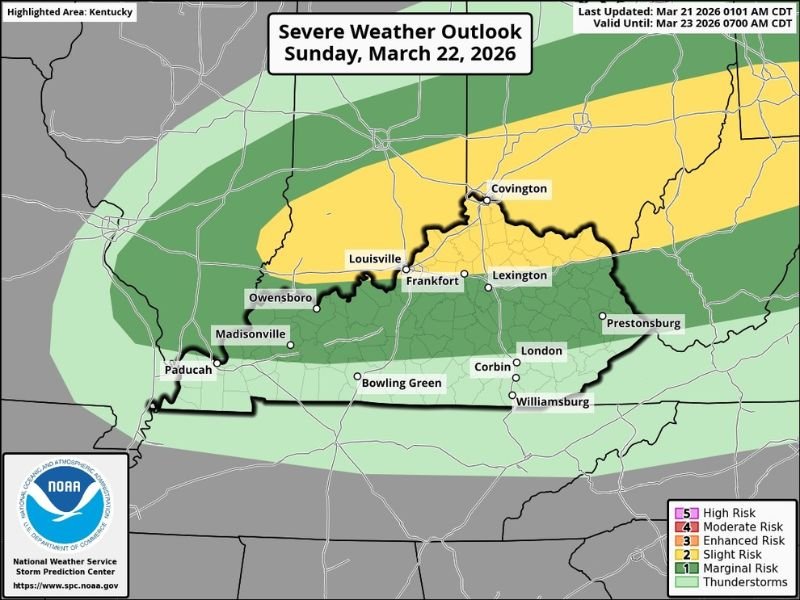
KENTUCKY — A developing severe weather threat is set to impact Kentucky late Sunday night, with forecasters highlighting a Level 2 out of 5 (Slight Risk) for storms capable of producing damaging winds, hail, and even isolated tornadoes.
The threat is expected to increase after 8 PM Eastern Time, making overnight conditions particularly important for residents across central and northern parts of the state.
Slight Risk Zone Covers Key Cities Including Louisville and Lexington
The yellow “slight risk” zone stretches across a large portion of northern and central Kentucky, including major population centers such as Louisville, Lexington, Frankfort, and Covington.
These areas face the highest potential for stronger storms capable of producing severe weather impacts. Surrounding regions, including Owensboro, Madisonville, Bowling Green, London, Corbin, and Prestonsburg, fall under a marginal (Level 1) risk, where storms are expected to be weaker but still capable of isolated impacts.
Tornado Wind and Hail Risks Defined
Forecasters have outlined specific probabilities associated with this system, giving a clearer picture of potential hazards.
Within the slight risk area:
- 2 percent chance of tornado development
- 15 percent risk of damaging winds
- 15 percent risk of large hail
In the marginal risk zones:
- 0 percent tornado risk
- 5 percent chance of damaging winds
- 5 percent risk of hail
While the tornado risk remains relatively low, it is not zero in key areas, meaning isolated spin-ups cannot be ruled out.
Timing Points to Late Evening and Overnight Storms
The most concerning aspect of this system is its late timing, with storms expected to develop and move through after 8 PM ET.
Nighttime severe weather can be especially dangerous because:
- Visibility is reduced
- Residents may be asleep when warnings are issued
- Storms can intensify quickly without being easily noticed
This makes it critical for residents to have multiple ways to receive alerts overnight.
Storm Coverage and Movement Across Kentucky
Storms are expected to develop to the west and move eastward across Kentucky, impacting areas in sequence from Paducah and western Kentucky toward Louisville, Lexington, and eastern regions.
The strongest storms will likely track through the northern and central corridor of the state, aligning with the highlighted slight risk zone.
What Residents Should Do Now
Residents across Kentucky should begin preparing ahead of Sunday night by reviewing safety plans and ensuring access to weather alerts.
Key recommendations include:
- Keep phones charged and emergency alerts enabled
- Identify a safe place in your home in case warnings are issued
- Stay updated with the latest forecasts as conditions evolve
Even though this is not a high-end outbreak, the combination of wind, hail, and isolated tornado potential means the situation should be taken seriously.
Forecasters will continue to refine details as the system approaches, but all signs point to a stormy and potentially hazardous Sunday night across Kentucky.

I’ve lived in Naperville long enough to see how quickly our community changes — from new developments downtown to sudden shifts in our Midwest weather. Reporting on Naperville news and daily forecasts gives me the chance to keep neighbors informed about what really matters. My goal is simple: deliver clear, timely updates so you always know what’s happening in our city and what to expect from the skies above.