
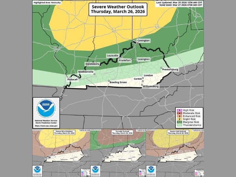
Kentucky Severe Weather Threat Stays Focused North of Louisville, Lexington and Covington Thursday While Southern Areas See Rain, Small Hail and Gusty Winds
LOUISVILLE, KENTUCKY — Kentucky’s Thursday weather setup is drawing attention for a north-to-south split in storm impacts, with the primary severe weather threat expected to stay focused across the northern part of the state while southern Kentucky sees a more limited setup. The overall pattern places areas near Louisville, Frankfort, Lexington, Covington, and Owensboro closer to the stronger side of the outlook, while locations farther south are expected to deal mainly with rain showers and lower-end storm impacts.
That difference matters because not every part of Kentucky is facing the same level of concern. The maps show the more meaningful severe weather risk lining up across northern counties, with the threat easing steadily farther south toward Bowling Green, Corbin, London, Williamsburg, and surrounding communities.
Northern Kentucky Sits Closer to the Main Severe Corridor
The risk maps clearly place northern Kentucky nearest the primary severe weather zone for Thursday. Communities near Covington, Louisville, Frankfort, Lexington, and Owensboro are closer to the area where stronger storms could organize as the system moves through the Ohio Valley.
This northern placement is important because it keeps Kentucky near the southern edge of a broader regional outbreak zone. In setups like this, even being just south of the highest-risk corridor can still bring changing weather quickly, especially for counties near the Ohio River and in north-central parts of the state.
Louisville, Lexington and Covington Near the More Active Part of the Outlook
Cities such as Louisville, Lexington, and Covington appear closer to the stronger wind, hail, and tornado outlook zones shown on the maps. That does not automatically mean these cities will experience the worst conditions, but it does place them in the part of the state where storms may have a better chance to intensify if the atmosphere becomes more favorable.
The outlook suggests that northern Kentucky has the best overlap with stronger storm ingredients. That includes the potential for more organized thunderstorms compared with southern sections of the state, where the environment appears less supportive of widespread severe weather.
Southern Kentucky Expected to See More Limited Impacts
Farther south, the forecast becomes less aggressive. Areas including Bowling Green, Corbin, London, Williamsburg, and parts of southern Kentucky appear more likely to see plain rain showers, perhaps a little small hail, and wind gusts in the 35 to 45 mph range at times.
Those wind speeds are still strong enough to be noticeable, especially with passing showers, but they remain below traditional severe limits. That means southern Kentucky may still have a messy and breezy day, just without the same level of concern that exists farther north.
Wind, Hail and Tornado Risks All Increase Toward the North
The smaller maps included with the outlook show that wind, tornado, and hail concerns all trend higher across northern Kentucky. The wind outlook pushes more meaningful risk closer to the northern half of the state, while the tornado outlook also favors areas nearer the northern border. The hail map follows a similar pattern, again showing the better overlap with stronger storm potential across northern sections.
Taken together, these maps reinforce the same message: Kentucky is involved in Thursday’s weather setup, but the greatest concern is not spread evenly statewide. Instead, the threat is weighted toward the north, where the state sits closer to the heart of the broader Ohio Valley storm corridor.
Why the Statewide Difference Matters
This kind of split forecast is important because it changes how residents should think about the day depending on where they live. Someone in Covington or Louisville may need to watch forecast updates more closely for stronger storms, while someone farther south may mainly be preparing for periods of rain and gusty but sub-severe winds.
That does not mean southern Kentucky should ignore the forecast. Even lower-end storms can still create travel issues, brief bursts of hail, and difficult driving conditions under heavier showers. But the more serious all-hazards severe setup appears positioned to the north of the state’s southern counties.
What Happens Next
Thursday’s forecast will continue to be refined as newer data comes in and storm timing becomes clearer. The biggest question for Kentucky is how far south the stronger storm ingredients can reach and whether northern parts of the state get pulled more directly into the higher-end side of the event.
For now, the clearest signal is that Kentucky’s main severe weather concern is strongest across the northern tier, while southern parts of the state are more likely to see ordinary showers, isolated small hail, and gusty winds below severe levels. Stay with NapervilleLocal.com for continued updates as Kentucky’s Thursday storm setup becomes clearer.

I’ve lived in Naperville long enough to see how quickly our community changes — from new developments downtown to sudden shifts in our Midwest weather. Reporting on Naperville news and daily forecasts gives me the chance to keep neighbors informed about what really matters. My goal is simple: deliver clear, timely updates so you always know what’s happening in our city and what to expect from the skies above.