
Kentucky Winter Storm Trend Signals Snow on Saturday Before Freezing Rain and Sleet Increase Sunday
Kentucky — The latest forecast trend indicates a developing winter weather system that is expected to start with widespread snow on Saturday, followed by a transition toward sleet and freezing rain on Sunday, January 26, 2026. The most important signal in the data shows the freezing rain and sleet line pushing deeper into Kentucky, changing how impacts may unfold as the system evolves.
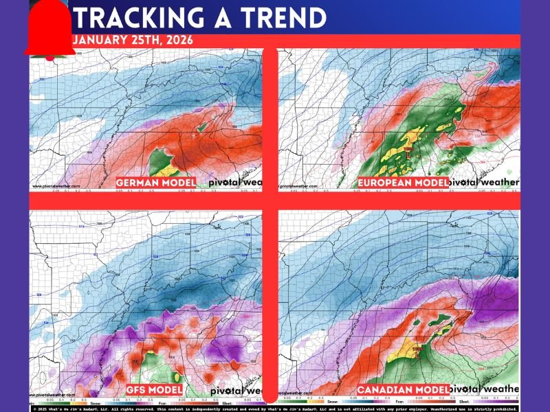
What the Current Forecast Trend Shows
Based strictly on the current model run discussed, snow remains the primary precipitation type at the start of the event. This early snow signal appears widespread before warmer air aloft begins influencing precipitation type later in the event.
As the system progresses:
- Snow is favored during the initial phase on Saturday
- Sleet and freezing rain become more likely on Sunday
- The freezing line advances farther into Kentucky than earlier runs suggested
This evolving setup is why forecasters are focusing on precipitation trends instead of snowfall totals.
Why Snowfall Totals Are Not Being Released Yet
The forecast discussion clearly explains why no snowfall map with specific numbers has been issued. Each time snowfall totals appear prematurely, they fail to reflect the growing risk of ice replacing snow.
Key reasons totals are being avoided include:
- Small temperature changes could dramatically alter outcomes
- Snow totals do not account for freezing rain and sleet impacts
- The forecast remains trend-based rather than finalized
At this stage, everything shown represents model guidance trends, not locked-in forecasts.
Model Trends and Forecast Confidence
The guidance emphasizes that:
- Multiple model runs are still being evaluated
- Confidence is higher in the overall pattern than in exact impacts
- An early snow and ice forecast is expected once confidence improves
The forecaster notes that once the forecast is clearly drawn out, that will signal the point at which confidence has increased enough to formally own the prediction.
Main Message From the Data
The central takeaway from the given data is clear and focused:
- Snow is likely early in the event
- Ice becomes a growing concern later
- Kentucky is positioned where this transition matters most
All information shared so far reflects developing trends, not final determinations.
For continued monitoring as forecast confidence increases, readers can follow ongoing updates on NapervilleLocal.com.

I’ve lived in Naperville long enough to see how quickly our community changes — from new developments downtown to sudden shifts in our Midwest weather. Reporting on Naperville news and daily forecasts gives me the chance to keep neighbors informed about what really matters. My goal is simple: deliver clear, timely updates so you always know what’s happening in our city and what to expect from the skies above.