
La Niña Pattern Signals Colder Second Half of January for Pennsylvania, New Jersey, and Delaware With Risk of 20–25 Inch Snowstorms
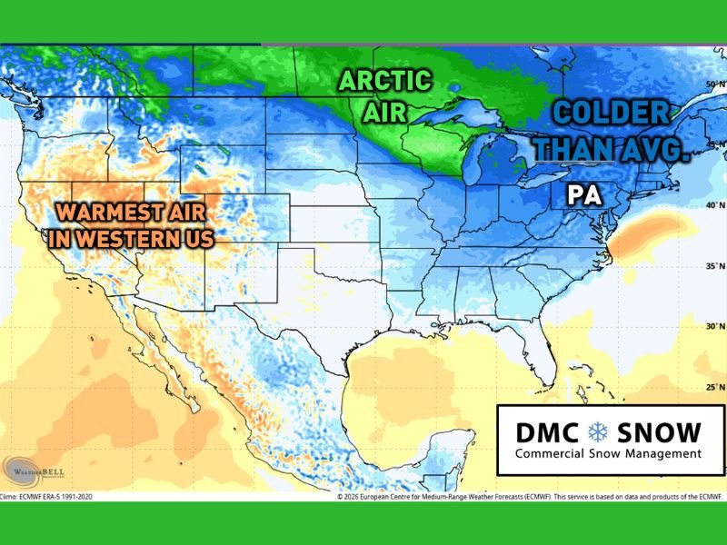
PENNSYLVANIA, NEW JERSEY, AND DELAWARE — Forecast guidance is increasingly pointing toward a major weather pattern shift after January 15, with La Niña conditions favoring colder-than-average temperatures across the eastern United States, including Pennsylvania, New Jersey, and Delaware. Temperature anomaly data shows Arctic air expanding south and east, a setup that historically increases winter storm potential in the Mid-Atlantic.
While a specific coastal storm next week remains uncertain, meteorologists say confidence is growing that the second half of January will turn noticeably colder, creating multiple opportunities for snow, especially if cold air aligns with available moisture.
January 15 Marks the Expected Pattern “Flip”
Long-range models indicate the official pattern flip around January 15, when Arctic air is expected to intrude more consistently into the central and eastern U.S. This shift replaces the stop-and-go cold seen earlier in the month with more sustained below-average temperatures. At the same time, warmer air remains locked over the western U.S., reinforcing a strong east-west contrast. That configuration often supports longer-lasting cold spells across PA, NJ, and DE rather than brief cold shots.
What La Niña Means for Snow Frequency and Intensity
Under La Niña, climatology typically favors more frequent light to moderate snow events rather than constant major storms. Forecasters expect a more active winter pattern, similar to December, with several opportunities for accumulating snow.
However, La Niña does not eliminate the risk of a larger storm. If a system taps into Gulf moisture while Arctic air is in place, the region could still experience a high-impact snow event, even if such storms are less common.
History Shows 20–25 Inch Snowstorms Are Still Possible
The 2020–2021 La Niña winter offers a clear reminder of what can happen when conditions align. Between January 30 and February 2, a major winter storm dropped 20 to 25 inches of snow in parts of eastern Pennsylvania, with significant impacts across the Mid-Atlantic. That storm occurred despite climatological odds favoring smaller events, underscoring why forecasters stress that large snowstorms cannot be ruled out later this month if cold air and moisture overlap.
What Residents in PA, NJ, and DE Should Expect
As the colder pattern settles in, snow chances will increase across multiple systems, even if not every storm is extreme. Repeated cold and snow events can still disrupt travel, stress infrastructure, and impact daily routines across the region.
Meteorologists emphasize that storm-by-storm details will become clearer closer to each event, but the overall signal points to a colder, more active second half of January compared to the start of the month. Staying informed will be key as winter conditions evolve. For continued coverage of Arctic air intrusions, La Niña impacts, and snowstorm risks across the U.S., visit NapervilleLocal.com, where we track the weather signals that matter.

I’ve lived in Naperville long enough to see how quickly our community changes — from new developments downtown to sudden shifts in our Midwest weather. Reporting on Naperville news and daily forecasts gives me the chance to keep neighbors informed about what really matters. My goal is simple: deliver clear, timely updates so you always know what’s happening in our city and what to expect from the skies above.