
Lake-Effect Snow to Hammer Michigan’s Upper Peninsula with Up to 12 Inches as Winter Alerts Blanket Region Through Wednesday
MICHIGAN — A passing winter system combined with strengthening lake-effect snow is set to bring widespread accumulation across Michigan through Wednesday, with the Upper Peninsula facing the highest totals and winter alerts now issued region-wide.
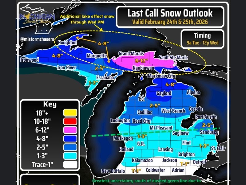
The latest snowfall outlook, valid February 24th through February 25th, shows only minor adjustments from earlier projections — but one key addition stands out: a newly expanded 6–12 inch zone across the eastern Upper Peninsula, driven by backside lake-effect snow persisting into Wednesday evening.
Upper Peninsula: 6–12 Inches Possible
Communities including Grand Marais, Naubinway, and areas near Sault Ste. Marie are forecast to receive between 6 and 12 inches of snow, especially where lake-effect bands intensify.
Farther west, areas such as Houghton, Marquette, Ironwood, and Iron River are projected to see 4–8 inches, with lake-effect continuing even after the main system exits.
Lake-effect snow may linger into Wednesday afternoon and evening, particularly across the eastern Upper Peninsula.
Northern Lower Michigan: 2–8 Inches
In northern Lower Michigan, totals will vary:
- Gaylord and Alpena: 4–8 inches
- Traverse City (T.C.) and Cadillac: 2–5 inches
- West Branch and Oscoda: 2–5 inches
These regions will see steady snow as the front moves through Tuesday into Wednesday morning.
Southern Michigan: Lower Totals, Higher Uncertainty
Snowfall drops off significantly south of a dashed green line stretching roughly west to east across the state. This boundary marks the zone of greatest uncertainty, where daytime temperatures above 32°F and low-level dry air could limit accumulation.
Cities such as:
- Grand Rapids (G.R.)
- Lansing
- Mt. Pleasant
- Saginaw
- Flint
- Brighton
- Detroit
- Kalamazoo
- Jackson
are expected to receive 1–3 inches, with some areas near the Ohio border, including Adrian and Coldwater, seeing only a trace to 1 inch.
Timing and Travel Concerns
Snow will begin first in the Upper Peninsula west of Newberry, likely by midday Tuesday. The rest of the state will see precipitation develop later in the afternoon and evening, with southeastern Michigan potentially not seeing flakes until after 10 p.m. EST.
Gusty winds accompanying the system may reduce visibility to under half a mile in heavier bands, especially across northern and eastern sections. Travel could become difficult at times, particularly during peak snowfall rates.
Snow is expected to taper by midday Wednesday for most of the state, though lake-effect bands in the Upper Peninsula could persist into the evening.
What to Expect
- Widespread winter alerts across the Upper Peninsula
- Stronger lake-effect snow in eastern U.P.
- Reduced visibility in heavier bursts
- Lower totals south of I-94 due to warmer surface temperatures
Drivers are urged to use caution, turn on headlights and taillights in snow squalls, and allow extra time for travel. For continued Midwest weather updates and winter storm coverage, stay connected with NapervilleLocal.com.

I’ve lived in Naperville long enough to see how quickly our community changes — from new developments downtown to sudden shifts in our Midwest weather. Reporting on Naperville news and daily forecasts gives me the chance to keep neighbors informed about what really matters. My goal is simple: deliver clear, timely updates so you always know what’s happening in our city and what to expect from the skies above.