
Lake-Effect Winter Storm to Deliver Heavy Snow Across Northwestern Pennsylvania Through Wednesday Morning
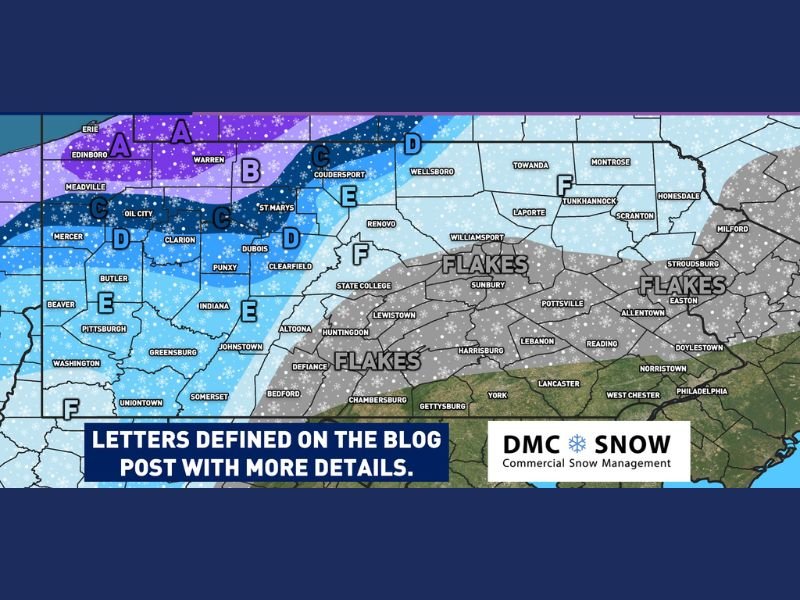
PENNSYLVANIA — A significant lake-effect snowstorm is underway across the northwestern part of the state, where forecasters warn that more than 10 inches of snow may accumulate by early Wednesday morning. While the heaviest totals remain near the Lake Erie snowbelt, lighter but still impactful snowfall is expected across central and northern sections of Pennsylvania.
This is only the first half of a two-part winter storm expected to persist into late week. A second round of snow is forecast to arrive from Wednesday afternoon through Friday morning, potentially adding to already substantial totals across several counties.
Heavy Bands to Focus on Northwestern Counties
The lake-effect setup is strongest across areas near Erie, Edinboro, Meadville, and Warren, where snowfall in excess of 10 inches is anticipated through Wednesday morning. The storm map highlights these northwestern counties within the highest-impact zone, where persistent bands of lake-induced moisture are expected to remain nearly stationary for long periods.
Farther south and east, communities including Butler, Clarion, St. Marys, Dubois, and Indiana fall into more moderate accumulation ranges. While totals here are projected to be lower, travel impacts may still develop as snow increases in intensity during the nighttime and early Wednesday hours.
Central and Eastern Pennsylvania to See Lighter Snow or Flurries
Areas from State College through Sunbury, Williamsport, Lebanon, Reading, and Allentown are projected to experience only light flakes or minor accumulations. While roadways may occasionally become slick, major disruptions are not expected. The southeastern part of the state, including Lancaster and West Chester, remains largely outside the heavier snow bands.
Forecasters emphasize that this map reflects only Round 1 of the storm system, and snow potential may increase again as the second wave arrives midweek.
More Snow Expected Wednesday Afternoon Through Friday
The current snowfall is only the beginning of a prolonged pattern expected to affect Pennsylvania through the end of the week. The second round, expected to begin Wednesday afternoon, may expand snowfall coverage farther south and east while reinforcing heavy totals in previously affected snowbelt areas.
Officials caution that new snowfall on top of early-week accumulation could increase the risk of travel hazards, particularly near the northwest counties closest to Lake Erie. More detailed forecasts, including region-by-region totals for part two of the storm, will be available as updated data becomes available.
Residents across Pennsylvania are encouraged to monitor forecasts closely and plan travel with caution as additional rounds of lake-effect snow continue into Friday. For ongoing weather updates and safety information, stay connected with NapervilleLocal.com.

I’ve lived in Naperville long enough to see how quickly our community changes — from new developments downtown to sudden shifts in our Midwest weather. Reporting on Naperville news and daily forecasts gives me the chance to keep neighbors informed about what really matters. My goal is simple: deliver clear, timely updates so you always know what’s happening in our city and what to expect from the skies above.