
Large Hail Pounds Logansport as Severe Thunderstorm Warning Covers Cass, Fulton, and Miami Counties Early Thursday Morning
INDIANA — A powerful early-morning thunderstorm brought very large hail into the Logansport area around 4:16 a.m. EST, prompting a new severe thunderstorm warning for parts of Cass, Fulton, and Miami counties.
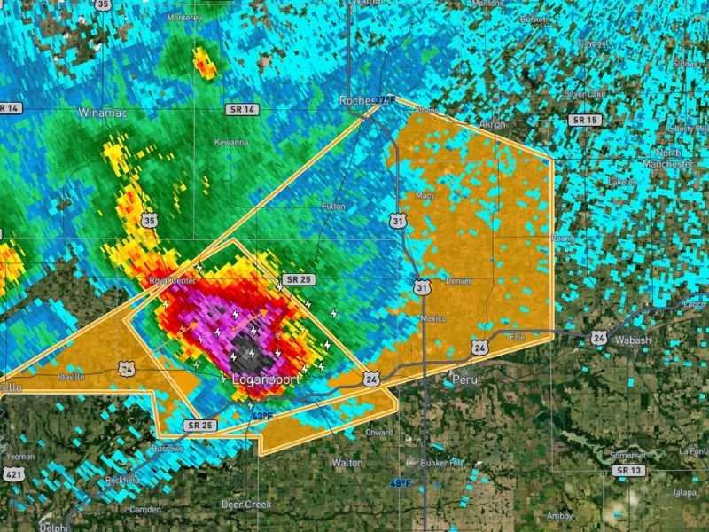
Radar imagery shows an intense core centered near Logansport, with the strongest reflectivity indicating large hail falling in and around the city. The warning remains in effect until 5:00 a.m. EST.
Hail Up to 1.25 Inches Reported
Forecasters warn that hail up to 1.25 inches in diameter is expected with this storm — roughly the size of a half-dollar coin. A few isolated hailstones larger than that are also possible within the most intense part of the storm.
The radar presentation shows a tightly packed core of extreme reflectivity directly over Logansport, extending west toward Royal Center and northward in the direction of Rochester. Drivers along State Road 25, U.S. 24, and U.S. 35 in the warned area could encounter rapidly deteriorating conditions.
Storm Tracking Northeast at 45 MPH
The storm is moving quickly — tracking off to the northeast at approximately 45 mph.
Communities in the path include:
- Logansport
- Royal Center
- Rochester
- Areas near Fulton
- Northern portions of Miami County
Residents in Peru, Denver, Macy, and surrounding rural areas should remain alert as the storm continues its northeast progression.
Lightning and Heavy Rain Accompanying the Core
In addition to large hail, frequent lightning and torrential rain are occurring within the strongest part of the cell. Visibility may drop rapidly in heavier downpours, especially along major roadways including U.S. 31 and State Road 24.
Given the speed of the storm, impacts in any one location may be brief but intense.
What Residents Should Do
With large hail possible, residents are advised to:
- Move vehicles into garages or covered areas if possible
- Stay indoors and away from windows
- Avoid unnecessary travel until the storm passes
This remains an active severe thunderstorm situation across north-central Indiana early Thursday morning.
For continued updates on severe weather events impacting Indiana and surrounding states, stay with NapervilleLocal.com as conditions evolve.

I’ve lived in Naperville long enough to see how quickly our community changes — from new developments downtown to sudden shifts in our Midwest weather. Reporting on Naperville news and daily forecasts gives me the chance to keep neighbors informed about what really matters. My goal is simple: deliver clear, timely updates so you always know what’s happening in our city and what to expect from the skies above.