
Last Night: Multiple Tornado Warnings Issued Across Southwest Michigan With Kalamazoo County Seeing Highest Activity
MICHIGAN — A volatile severe weather setup came extremely close to producing a significant tornado event across southwest Michigan last night, April 2nd. Multiple rotating storm cells moved through the region, prompting several tornado warnings and creating dangerous conditions across multiple counties.
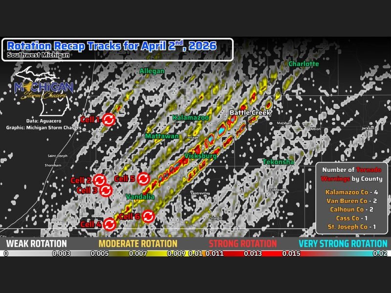
Six Storm Cells Trigger Multiple Tornado Warnings
A total of six primary storm cells were responsible for five separate tornado warnings issued by National Weather Service offices in Grand Rapids and North Webster.
Strong wind shear in the atmosphere—measured at three to five times typical values—created an environment supportive of storm rotation as the system moved into Michigan.
Kalamazoo County Saw Highest Warning Activity
Kalamazoo County experienced the most intense activity, with four tornado warnings issued throughout the evening, more than any other county.
Nearby areas also saw notable storm rotation, including:
- Van Buren County
- Calhoun County
- Cass County
- St. Joseph County
These regions experienced varying levels of rotation as storms tracked through.
Battle Creek Narrowly Avoids Direct Impact
Battle Creek was described as one of the luckiest locations during the event, as two strong rotational signatures passed through different parts of the city within 45 minutes.
Despite the close calls, no confirmed tornado touchdowns were reported in these areas.
Additional Rotation Observed Across Multiple Areas
Weaker pockets of rotation were also detected near:
- Tekonsha
- Union City
- Sturgis
These areas experienced lower-end rotation compared to the more intense cells further west.
Storms Weakened Before Producing Major Tornadoes
As storms advanced into Michigan, slightly lower instability and changing conditions helped slow storm intensity, preventing a higher-end tornado outbreak.
While brief spin-up tornadoes cannot be completely ruled out, no confirmed touchdowns have been reported.
Strong Public Response and Early Warnings Helped Reduce Risk
Over 500,000 viewers tuned in to live severe weather coverage, helping residents stay informed and take shelter when needed.
Timely warnings from National Weather Service offices ensured that no major rotational cell went unwarned, contributing to a safer outcome despite the dangerous setup.
Close Call Highlights Importance of Preparedness
This event serves as a reminder of how quickly severe weather conditions can escalate, especially when atmospheric ingredients align.
Although the worst-case scenario was avoided, the presence of multiple rotating storms underscores the importance of staying alert during severe weather events. Stay with NapervilleLocal.com for the latest weather updates and local forecast coverage.

I’ve lived in Naperville long enough to see how quickly our community changes — from new developments downtown to sudden shifts in our Midwest weather. Reporting on Naperville news and daily forecasts gives me the chance to keep neighbors informed about what really matters. My goal is simple: deliver clear, timely updates so you always know what’s happening in our city and what to expect from the skies above.