
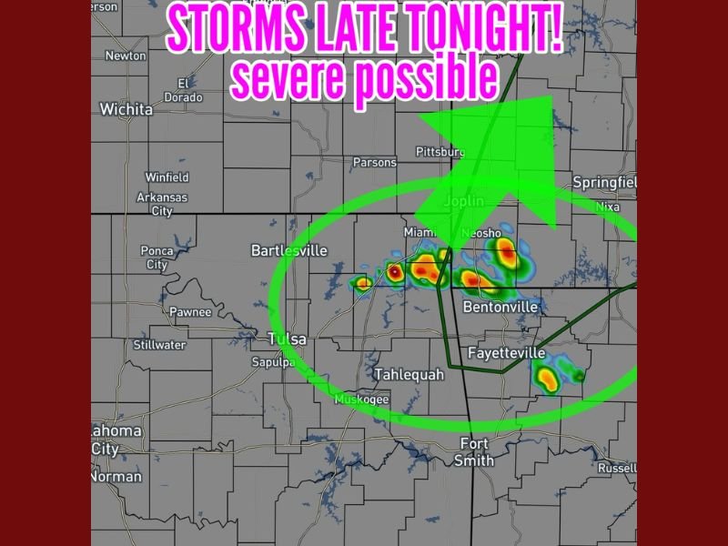
Late-Night Storms Expected in Northeast Oklahoma With Potential for Marginally Severe Hail as Cells Move Into Missouri and Northwest Arkansas
NORTHEAST OKLAHOMA — Forecasters are tracking the potential for late-night thunderstorms to develop across far northeast Oklahoma, with activity expected mainly after 10 PM before moving northeast into Missouri and northwest Arkansas. Some of these storms may be capable of producing marginally severe hail, particularly within the stronger cells that form along the developing line.
Timing and Development of Tonight’s Storms
Meteorologists say conditions are becoming increasingly favorable for scattered storm development late tonight. Radar projections show clusters of thunderstorms forming near the Bartlesville–Miami–Tahlequah corridor, with storms then drifting toward Joplin, Neosho, and portions of northwest Arkansas.
Key timing details include:
- Storm initiation expected after 10 PM
- Movement trending northeast overnight
- Stronger storm cells capable of producing hail near severe limits
While widespread severe weather is not expected, forecasters emphasize that isolated pockets of hail or brief intense downpours may accompany the stronger storms.
Areas Most Likely to Be Affected
Forecast maps highlight a zone from northeast Oklahoma into southwest Missouri and northwest Arkansas where thunderstorms are most likely to develop. Cities and regions under the greatest threat include:
- Bartlesville
- Miami, OK
- Neosho and Joplin, MO
- Bentonville and Fayetteville, AR
- Surrounding rural areas and nearby counties
Residents in these locations may experience frequent lightning, brief heavy rain, and gusty winds, along with the potential for hail up to the marginal severe threshold.
What Residents Should Watch for Overnight
As storms build and shift northeastward, meteorologists advise residents to monitor local alerts and be prepared for:
- Small hail near or slightly above one inch in diameter
- Rapidly changing weather conditions after 10 PM
- Isolated stronger thunderstorms capable of intensifying briefly
- Possible minor travel impacts from heavy rain or reduced visibility
While tornado risk remains very low, forecasters stress that any late-night storm can still be disruptive, especially for those traveling or working overnight.
More refined details will be available as radar trends evolve through the evening.
For continuing updates on severe weather threats, storm timing, and overnight conditions across the region, stay connected with NapervilleLocal.com.

I’ve lived in Naperville long enough to see how quickly our community changes — from new developments downtown to sudden shifts in our Midwest weather. Reporting on Naperville news and daily forecasts gives me the chance to keep neighbors informed about what really matters. My goal is simple: deliver clear, timely updates so you always know what’s happening in our city and what to expect from the skies above.