
Light Freezing Rain and Sleet Expected Monday Morning Across Oklahoma, Texas, Missouri, and Arkansas
OKLAHOMA — Weather forecasters are warning residents across parts of Oklahoma, northern Texas, southern Kansas, southwest Missouri, and northwest Arkansas to prepare for a light wintry mix of freezing drizzle and rain early Monday morning that could create slick spots on elevated surfaces.
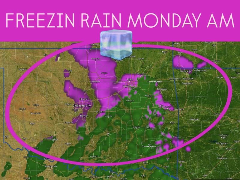
The latest high-resolution weather guidance shows a narrow but persistent band of light freezing rain developing before sunrise Monday, primarily affecting central and northeastern Oklahoma, including areas near Oklahoma City, Tulsa, and Stillwater, before drifting eastward into Arkansas and southern Missouri.
Light Accumulations Expected, But Caution Advised
According to meteorologists, temperatures will hover near the freezing mark, limiting the overall accumulation of ice. However, even a thin glaze of freezing rain or sleet can make bridges, overpasses, and untreated roads slippery, particularly during the early commute.
“Amounts will be light and temperatures marginal,” forecasters said, “but motorists should remain cautious of slick conditions, especially on elevated roadways.”
The freezing rain zone could briefly extend south into northwest Texas, including areas near Wichita Falls and Lawton, where surface temperatures may dip just low enough for a light coating of ice before transitioning back to plain rain by mid-morning.
Areas Most Likely to See Impacts
Meteorologists expect the most noticeable effects in:
- Central and northeast Oklahoma — including Oklahoma City, Tulsa, Norman, and Stillwater
- Southern Kansas — near Coffeyville and Independence
- Southwest Missouri — around Springfield and Joplin
- Northwest Arkansas — including Fayetteville and Fort Smith
Precipitation is expected to remain spotty and light, but travelers and early commuters should drive slowly and stay weather-aware, as conditions can change quickly on bridges and ramps.
Timing and Temperature Trends
The freezing rain risk is projected to begin early Monday morning (between 4 a.m. and 9 a.m.) before warmer air pushes into the region later in the day, transitioning precipitation to plain rain.
By afternoon, temperatures should climb into the upper 30s and low 40s across much of the region, ending the freezing concern.
Outlook After Monday
Following this brief bout of icy weather, forecasters expect a gradual warm-up through midweek as southerly winds return, bringing milder air across the Southern Plains. No additional winter weather is expected immediately afterward.
Residents are encouraged to monitor local forecasts closely and check for possible travel advisories in affected areas Monday morning.
Stay informed on changing weather patterns and regional updates by visiting NapervilleLocal.com for the latest weather alerts and community coverage.

I’ve lived in Naperville long enough to see how quickly our community changes — from new developments downtown to sudden shifts in our Midwest weather. Reporting on Naperville news and daily forecasts gives me the chance to keep neighbors informed about what really matters. My goal is simple: deliver clear, timely updates so you always know what’s happening in our city and what to expect from the skies above.