
Light Snow Expected Across Washington, Oregon, and Idaho Tonight Into Sunday Morning as Quick-Moving System Passes Through
WASHINGTON — A quick-moving upper-level system will bring light snow across south-central and southeastern Washington into eastern Oregon and Idaho tonight into early Sunday morning, marking the first measurable snowfall of the season for several inland Northwest communities.
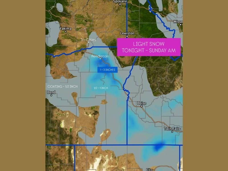
Meteorologists say a northwest flow across the Pacific Northwest is helping this system dive southeast, spreading an area of light precipitation from Yakima and Pendleton to Boise and Twin Falls. Although much of the atmosphere remains dry, forecasters believe some snowflakes will make it to the surface overnight, particularly in higher elevations.
Quick-Moving System Bringing Patchy Snow Across the Region
The latest forecast shows light snow developing late Saturday evening and continuing through Sunday morning, with the heaviest totals expected in elevated areas such as the Blue and Strawberry Mountains.
According to the National Weather Service, accumulations will generally range from a dusting up to 3 inches, depending on location and elevation.
- Pendleton, OR: 1–3 inches possible
- Boise, ID: Trace to 1 inch
- Tri-Cities, WA: Light flurries or coating under ½ inch
- Bend, OR: Around ½ inch possible
- Twin Falls, ID: Light snow possible through early Sunday
Meteorologists note that this will not be a major winter storm, but enough lift will develop in the mid-levels of the atmosphere to generate scattered snow showers overnight.
Dry Air May Limit Totals, But Flurries Likely in Many Areas
Despite widespread radar returns, much of the region remains under dry low-level air, which may limit how much snow reaches the ground. However, forecasters say that as the system deepens overnight, snowflakes should begin reaching surface levels, especially in valley areas like the lower Columbia Basin and Snake River Valley.
“The setup is classic for a light, quick burst of snow across the Northwest,” forecasters explained. “Even though it’s not a major event, it could bring the first true dusting of the season to parts of eastern Washington and western Idaho.”
Early Winter Chill to Follow the System
Behind this disturbance, temperatures will fall into the 20s and low 30s by early Sunday morning, creating the potential for slick spots on bridges, overpasses, and untreated roadways. Residents traveling along Interstate 84 between Pendleton and Boise are advised to drive cautiously.
As skies clear on Sunday, colder air will linger through the day, keeping highs well below normal for late November.
This light snow system marks the beginning of a pattern shift toward colder, more active weather across the Northwest heading into December.
For ongoing updates on snowfall totals and travel conditions across the region, stay connected with NapervilleLocal.com.

I’ve lived in Naperville long enough to see how quickly our community changes — from new developments downtown to sudden shifts in our Midwest weather. Reporting on Naperville news and daily forecasts gives me the chance to keep neighbors informed about what really matters. My goal is simple: deliver clear, timely updates so you always know what’s happening in our city and what to expect from the skies above.