
Light Snow Expected Tonight Across Central Washington as Upper-Level System Moves Through Kittitas and Yakima Valleys
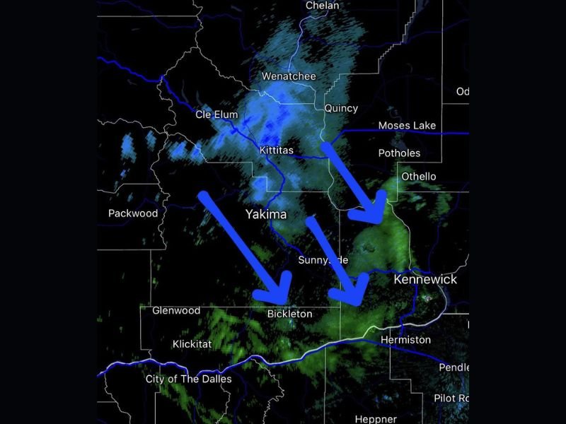
WASHINGTON — Radar imagery late Friday evening shows light precipitation developing over the Kittitas Valley and Yakima areas as an upper-level disturbance slides southeast across Central Washington. While most of the returns are not yet reaching the ground, forecasters say light snow may begin falling later tonight, especially across Yakima County and the Tri-Cities region.
At 5:20 p.m. Pacific time, weather radar indicated developing snow bands north and west of Yakima, extending toward Cle Elum, Kittitas, and Quincy, with moisture gradually shifting southeast toward Kennewick and Richland.
Light Snow Expected Overnight
Meteorologists note that while the air near the surface remains somewhat dry, continued cooling and moisture from the upper atmosphere will help snowflakes begin reaching the ground overnight, particularly after midnight.
“Radar returns are increasing in coverage, and some of that will start to reach the surface later this evening,” forecasters explained. “A dusting to light accumulation is possible, especially on grassy or elevated surfaces.”
The Tri-Cities area — including Kennewick, Pasco, and Richland — may see light flurries or trace accumulations, with the best chances near Bickleton and Sunnyside. Meanwhile, the Kittitas Valley and higher elevations surrounding Yakima and Cle Elum could pick up a light coating of snow, though major impacts are not anticipated.
Forecast and Regional Impacts
- Yakima & Kittitas Valleys: Chance of light snow late tonight into early Saturday morning; minor accumulations under 1 inch possible.
- Tri-Cities Area: Scattered flurries or brief snow showers possible overnight.
- Wenatchee & Quincy: Light snow or mixed precipitation possible early evening before tapering off.
Road temperatures are expected to remain near or slightly above freezing in many areas, so significant travel issues are not expected, though drivers should still exercise caution during the early morning commute.
Upper-Level System to Move Out by Saturday
The upper-level disturbance responsible for tonight’s light snow will move out of the region by Saturday morning, leading to clearing skies and a return to cold, dry conditions across Central Washington.
This system marks one of the first signs of increasing winter activity in the Pacific Northwest, as forecasters expect more widespread snow chances next week with another round of colder air arriving from the north.
Stay informed on developing weather conditions and forecasts across the Pacific Northwest by visiting NapervilleLocal.com for continuous coverage and local weather updates.

I’ve lived in Naperville long enough to see how quickly our community changes — from new developments downtown to sudden shifts in our Midwest weather. Reporting on Naperville news and daily forecasts gives me the chance to keep neighbors informed about what really matters. My goal is simple: deliver clear, timely updates so you always know what’s happening in our city and what to expect from the skies above.