
Limited Snow Expected Tonight Across Eastern Pennsylvania and New Jersey as Rain Changes to Wet Snow Before Dawn Monday
Philadelphia, Pennsylvania — A weak weather system will move through the region tonight, bringing a period of rain changing to wet snow, with limited accumulations expected before ending early Monday morning. The system is not expected to produce significant travel disruptions, but some areas north and west of Interstate 95 could see a light coating to a couple of inches of snow by sunrise.
The storm timeline shows precipitation beginning around 6 p.m. in western areas and spreading eastward to reach all locations by approximately 8 p.m. The system is expected to wind down by 4 a.m. Monday, limiting the window for accumulation.
Rain First, Then Wet Snow Late Tonight
Most communities will begin the evening with plain rain, as temperatures remain at or slightly above freezing. By around 11 p.m., colder air filtering into the region will allow rain to transition into wet snow, especially across inland and elevated areas.
However, forecasters note that temperatures hovering near the freezing mark will reduce snow accumulation efficiency. The wet nature of the snow combined with marginal temperatures will likely limit totals on road surfaces, with grassy and elevated surfaces more likely to see minor buildup.
Highest Snow Totals North and West of I-95
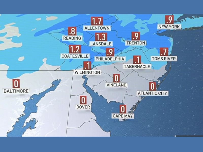
The most favorable zone for accumulation includes areas along and west of Interstate 95, and north of Interstate 195. Forecast projections indicate:
- Allentown: 1.7 inches
- Lansdale: 1.3 inches
- Coatesville: 1.2 inches
- Reading: 0.8 inches
- Trenton: 0.9 inches
- Philadelphia: 0.9 inches
- Wilmington: 0.1 inches
Farther south and east, totals drop off significantly. Locations such as Vineland, Atlantic City, Dover, and Cape May are expected to see mainly rain, with little to no snow accumulation.
Along the Jersey Shore, including Toms River (0.7 inches) and coastal communities near Atlantic City, precipitation is expected to remain mostly rain due to slightly warmer marine air.
Minimal Travel Impacts Expected
Because snowfall rates are expected to remain light and temperatures will stay near freezing, widespread road issues are not anticipated. Any slick spots that do develop are most likely on untreated secondary roads and elevated surfaces late tonight. By early Monday morning, the system will exit the region, allowing conditions to gradually improve.
While this event is not a major winter storm, it serves as a reminder that late-season systems can still bring brief bursts of snow, particularly north and west of major urban corridors. For continued coverage of regional weather developments and national storm updates, visit NapervilleLocal.com for the latest forecasts and detailed analysis.

I’ve lived in Naperville long enough to see how quickly our community changes — from new developments downtown to sudden shifts in our Midwest weather. Reporting on Naperville news and daily forecasts gives me the chance to keep neighbors informed about what really matters. My goal is simple: deliver clear, timely updates so you always know what’s happening in our city and what to expect from the skies above.