
Long-Range Weather Models Hint at Possible Southern U.S. Snow Event in the January 7–9 Timeframe
UNITED STATES — New long-range model data is drawing attention to a possible winter event in the southern United States between January 7–9, as European ensemble guidance begins showing increased activity in that timeframe. While confidence remains low, forecasters say this is a window worth watching as winter patterns evolve.
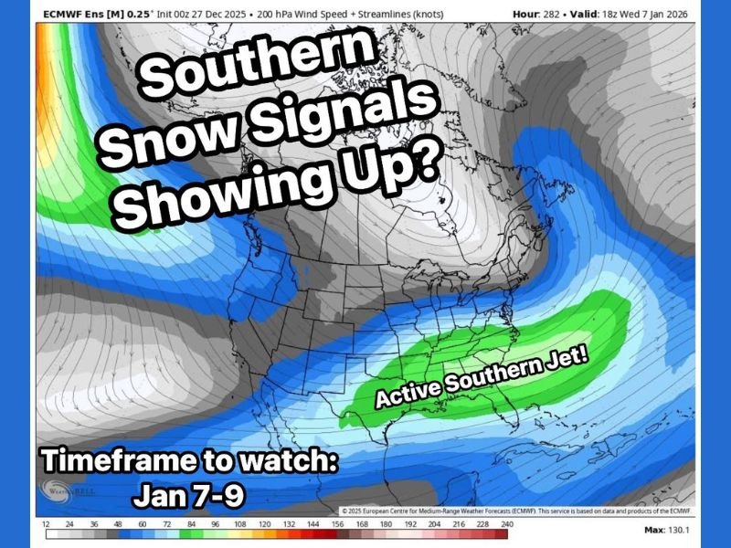
European Ensemble Blend Shows Early Signs of Southern Activity
What’s being shown is not a single computer model run, but the combined output of 51 European ensemble members. This blend highlights the potential for enhanced storm energy across the southern U.S. during the early January period.
Key model details:
- 51-member European ensemble blend
- Timeframe of interest: January 7–9
- Active southern jet stream displayed
Cold air is already established across parts of the country, which is an important factor. The question — still impossible to answer at this distance — is how close that cold air will be when any storm system develops.
Too Early for Specifics, but Consistency Matters
At this range, meteorologists emphasize the difficulty of pinpointing storm track, intensity, or precipitation type. No forecast is being made yet, only a pattern being recognized.
When both the European ensemble and the GFS repeatedly hint at similar ideas over several days, forecasters begin paying closer attention. The key factor now is consistency — whether these signals strengthen, fade, or shift in the coming model runs. One run means very little. Repeated runs showing similar trends help build confidence as the timeframe approaches.
Cold Air in Place, Active Jet Stream Showing Up
The active southern jet appearing on ensemble maps is a noteworthy feature. For a southern snow system to develop, two ingredients must align: moisture from the jet stream and cold air arriving at the right moment. At this stage, cold air is present in the broader pattern. But timing is everything — and too early to determine.
Monitoring Period Begins, Not a Forecast Yet
Forecasters stress that nothing is locked in. This is simply a signal, not a prediction. The next several days of model data will determine whether the signal strengthens or weakens. Residents across the South — as well as forecasters in the Midwest who track broader winter patterns — should follow updates as new runs are analyzed.
Early takeaways:
- A potential pattern, not a confirmed storm
- Confidence increases only with consistency
- Model guidance may shift significantly
More Information Expected as January Approaches
With more data arriving daily, meteorologists will monitor whether the January 7–9 window continues to show organized storm potential. If the pattern sharpens, details such as track and temperature profile will become clearer. Stay with NapervilleLocal.com for updated model trends, winter outlook discussions, and detailed analysis as we approach the early January timeframe.

I’ve lived in Naperville long enough to see how quickly our community changes — from new developments downtown to sudden shifts in our Midwest weather. Reporting on Naperville news and daily forecasts gives me the chance to keep neighbors informed about what really matters. My goal is simple: deliver clear, timely updates so you always know what’s happening in our city and what to expect from the skies above.