
Los Angeles County Braces for Early Morning Storms Bringing Waterspout and Tornado Threat Along the Coast
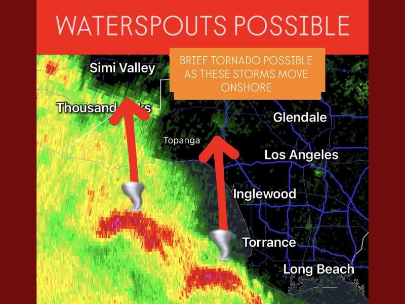
LOS ANGELES COUNTY, Calif. — Early Friday morning storms have prompted urgent weather alerts across Los Angeles County, where forecasters are warning of possible waterspouts over coastal waters and brief tornadoes as the system pushes inland toward populated areas like Thousand Oaks, Topanga, Inglewood, and Torrance.
According to the National Weather Service (NWS), radar detected strong rotation within cells just off the Southern California coast around 5:30 a.m. Pacific Time, with these storms showing signs capable of generating waterspouts, which could briefly intensify into tornadoes upon reaching land.
Meteorologists said these types of systems are common during late-autumn Pacific storm events, which combine warm ocean air and upper-level cold fronts to create volatile weather near the shoreline.
“We’re seeing strong low-level wind shear and instability over the coastal waters,” forecasters explained. “Any storms moving onshore this morning could spin up a brief tornado before weakening over land.”
Where the Risk Is Highest
The rotating storm cells are currently tracking northeast from the Pacific toward Los Angeles County’s coastal corridor, with the strongest impacts expected between Thousand Oaks, Topanga, and Inglewood. Communities from Santa Monica and Torrance down to Long Beach are also under elevated risk as the system progresses inland.
Primary threat areas include:
- Thousand Oaks and Simi Valley: Risk of waterspouts coming ashore with strong rotation signatures detected near the Ventura-L.A. County line.
- Topanga Canyon and Malibu coast: Heavy rainfall and strong gusts may accompany any rotating storms.
- Los Angeles and Inglewood metro area: Brief tornado potential, along with heavy rain and wind gusts up to 45–50 mph.
While the tornado threat remains isolated, forecasters warn that even weak, short-lived tornadoes can cause damage to vehicles, roofs, and power lines in densely populated zones.
Storm Behavior and Weather Dynamics
These storms are developing along a coastal boundary layer where warm, moist ocean air is colliding with colder air aloft. This sharp contrast is fueling rapid updrafts and allowing the storms to rotate — a necessary ingredient for waterspout formation.
Waterspouts — essentially tornadoes that form over water — can occasionally transition onto land, becoming brief but damaging tornadoes. This process typically lasts only a few minutes but can still produce wind gusts over 50 mph and isolated property damage.
Lightning, heavy rainfall, and localized flooding have also been reported along the coast, particularly near Malibu and Santa Monica, as the storm line moves northeast toward the Los Angeles metro area.
“People near the coast should stay indoors and away from windows until these storms pass,” the NWS said. “Conditions can change quickly, and visibility may drop to near zero in heavy rain.”
What Residents Should Expect Through the Morning
The heaviest rainfall and thunderstorm activity are expected through 8:00 a.m., with lingering showers continuing across the county through midday. Coastal and foothill communities may experience gusty winds, while urban areas face temporary street flooding and minor debris flow risks in burn scar zones.
Key impacts expected this morning include:
- Waterspouts and brief tornadoes: Possible from Malibu through Torrance as storms move inland.
- 50 mph wind gusts: Capable of knocking down small branches and causing spotty power outages.
- Heavy rain and low visibility: Travel disruptions likely on Pacific Coast Highway and I-405.
Air traffic delays at LAX are possible due to lightning proximity and rapid wind shifts, though no ground stops have been reported at this time.
Weather Safety Recommendations
Authorities are urging residents to remain vigilant and follow weather updates throughout the morning. Drivers should use caution on slick roads and avoid flooded intersections.
Safety officials also emphasize:
- Stay indoors until the storm passes.
- Avoid the beaches and piers where waterspouts may still occur.
- Report damage or funnel cloud sightings immediately to local law enforcement or the NWS.
Meteorologists say the atmosphere will stabilize later today, but another round of rain and scattered storms could develop over the weekend as another Pacific system approaches from the southwest.
Residents are encouraged to stay weather aware and monitor local alerts for real-time updates.
Have you witnessed this morning’s coastal storms in Los Angeles County? Share your photos and reports with NapervilleLocal.com.

I’ve lived in Naperville long enough to see how quickly our community changes — from new developments downtown to sudden shifts in our Midwest weather. Reporting on Naperville news and daily forecasts gives me the chance to keep neighbors informed about what really matters. My goal is simple: deliver clear, timely updates so you always know what’s happening in our city and what to expect from the skies above.