
Louisiana, Mississippi, Alabama, Georgia, Tennessee, Carolina, and Virginia Face Potential Freezing Rain Threat January 20–23
United States — Long-range forecast data for January 20–23 is signaling a significant freezing rain threat across portions of the Southern and Eastern United States, with early projections highlighting a corridor stretching from Louisiana, Mississippi, Alabama, and Georgia into Tennessee, South Carolina, North Carolina, and Virginia.
Although details remain uncertain at this range, the consistency of the signal indicates a developing high-impact winter setup capable of producing hazardous ice conditions across multiple states.
A Sudden Shift After Weeks of Mild Forecasts
Just days ago, long-range discussions suggested a relaxed winter pattern with no major systems on the horizon. That expectation has changed abruptly. New model signals show a sharp re-intensification of winter conditions, contradicting earlier calm-weather expectations.
The commentary circulating alongside the data — while humorous in tone — reflects a genuine atmospheric shift. Meteorologists referencing this pattern note that January appears ready to reassert itself after a brief lull, bringing back colder air and storm potential in a dramatic fashion.
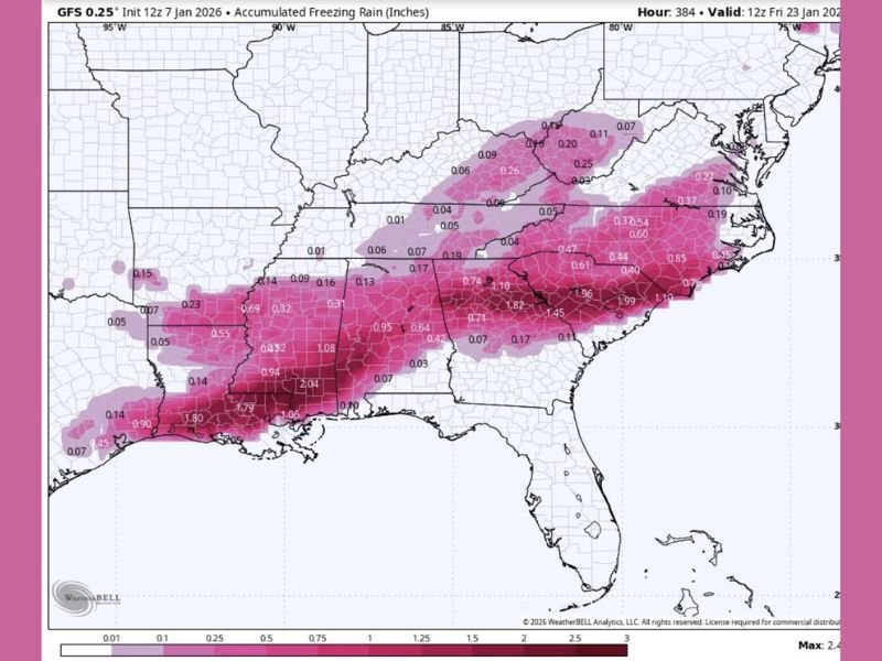
Freezing Rain Map Highlights a Broad Impact Zone
The forecast map shows varying levels of freezing rain potential across the following states:
- Louisiana: Some of the highest modeled accumulations, with pockets exceeding one inch
- Mississippi and Alabama: Widespread ice potential, including areas modeled above one inch
- Georgia: Strong signal for freezing rain, especially across central and northern regions
- Tennessee: Portions of the state indicated for moderate to locally higher accumulations
- South Carolina and North Carolina: Broad corridor of ice potential, with some areas approaching one inch
- Virginia: Northern extension of the freezing rain footprint
These early projections highlight a storm track that places cold surface air beneath warmer air aloft — the exact temperature structure that produces freezing rain instead of snow or sleet.
Why Ice Is a Concern in This Pattern
Meteorologically, the setup combines three ingredients:
- Cold surface air pushing southward
- Gulf moisture lifting north
- A warm layer above the surface
This causes precipitation to fall as liquid and freeze on contact when it reaches subfreezing surfaces. Such events can lead to:
- Downed tree limbs and power lines
- Roadway glazing and hazardous travel
- Widespread power outages in vulnerable areas
- Extended recovery periods, especially in regions unaccustomed to ice storms
Meteorologists emphasize that this is a signal, not a finalized forecast, but the early strength of the pattern warrants attention.
What Residents in Affected States Should Monitor
Over the next several days, residents in Louisiana, Mississippi, Alabama, Georgia, Tennessee, South Carolina, North Carolina, and Virginia should watch for:
- Updated freezing rain accumulation forecasts
- Shifts in storm timing
- Temperature profile adjustments
- Early advisories or watches
- Power infrastructure risk assessments
Even small temperature variations can significantly change outcomes in freezing rain events.
Looking Ahead
This long-range outlook does not indicate impacts for Illinois or the Midwest at this time. However, it represents an important national weather development, especially for travelers, students, and families with connections across the Southeast and Mid-Atlantic. NapervilleLocal.com will continue monitoring updated model runs and professional forecasts as confidence increases closer to the January 20–23 window.

I’ve lived in Naperville long enough to see how quickly our community changes — from new developments downtown to sudden shifts in our Midwest weather. Reporting on Naperville news and daily forecasts gives me the chance to keep neighbors informed about what really matters. My goal is simple: deliver clear, timely updates so you always know what’s happening in our city and what to expect from the skies above.