
Major Cold Front to Sweep From Texas to Tennessee After Thanksgiving, Bringing Early December Chill Across the Midwest and South
UNITED STATES — A powerful blast of Arctic air is forecast to sweep across much of the central and southern United States during the weekend after Thanksgiving, marking an early arrival of December’s coldest conditions. Meteorologists say the system could stretch from Texas through Tennessee, dropping temperatures to their lowest levels so far this season.
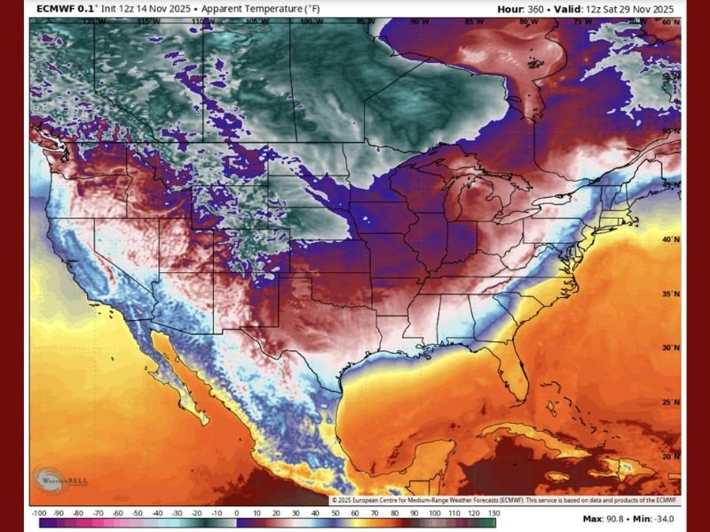
According to new forecast data from the European Centre for Medium-Range Weather Forecasts (ECMWF), the cold front will surge south and east by Saturday, November 29, 2025, bringing wind chills far below average across a wide swath of the country.
Early Winter Weather on the Move
Meteorologists from Gulf Coast Severe Weather & Tropics described the front as “a cold blast with an attitude problem,” warning that this early-season pattern is more aggressive than usual. The system is expected to plunge temperatures from the southern Plains through the Midwest and into the Deep South, leaving millions feeling a significant drop within just 24 hours.
“From Texas to Tennessee, it’s colder than your ex’s heart,” one forecast post joked — but behind the humor lies a serious shift in the nation’s weather pattern.
Model projections show apparent temperatures (the “feels like” factor) plummeting into the 20s and teens across the central U.S., while states such as Arkansas, Mississippi, and Alabama could experience lows near freezing. The Midwest, including Illinois, Indiana, and Kentucky, is expected to see biting wind chills that make it feel even colder.
Thanksgiving Leftovers Meet Arctic Air
The front is forecast to arrive just days after Thanksgiving, disrupting any lingering mild air and replacing it with a sharp, dry chill.
“This map looks like December didn’t stroll in — it slid in,” meteorologists wrote, likening the pattern’s arrival to “muddy boots on Grandma’s linoleum.”
Experts say the transition will be fast and jarring. Temperatures could fall 30 to 40 degrees in less than 48 hours in some regions as cold air surges southward. That means areas enjoying upper-60s to mid-70s before the holiday could see daytime highs struggling to reach the 40s by the weekend.
Areas Most Affected by the Temperature Drop
The early December chill will impact multiple states, with the strongest cold air pooling across the central and eastern U.S.:
- Texas and Oklahoma: Sharp temperature declines, with possible freezing conditions in northern Texas.
- Arkansas, Mississippi, Alabama: Temperatures dipping into the 30s and low 40s, with potential frost inland.
- Tennessee and Kentucky: Overnight lows expected in the 20s; brisk north winds may create icy conditions.
- Midwest (Illinois, Indiana, Ohio): Wind chills near or below freezing with possible early snow flurries north of I-80.
Forecasters note that Chicago and surrounding areas could feel subfreezing wind chills during morning hours, marking one of the first strong winter pattern shifts of the season.
What’s Behind the Sudden Cold Surge?
Meteorologists attribute the incoming cold blast to a strong upper-level trough dipping across the central United States. This pattern allows Arctic air from Canada to funnel southward, meeting residual Gulf moisture and setting the stage for windy, dry conditions behind the front.
“This is the classic setup where winter says, ‘Surprise! I’m early,’” weather experts noted, adding that this may be the first of several Arctic surges expected in early December.
Long-range models also hint at the possibility of another reinforcing cold wave in early December, suggesting the South and Midwest could remain in a below-average temperature pattern for several weeks.
Travel and Safety Precautions
With millions expected to be returning home from Thanksgiving celebrations, the post-holiday timing could complicate travel. Drivers are advised to prepare for:
- Slippery road conditions due to sudden freezes overnight.
- Reduced visibility in areas where cold air meets lingering moisture.
- Wind chills that could cause frostbite risk during extended outdoor exposure.
Residents in the affected regions should also take steps to protect pets, plants, and plumbing, especially in areas unaccustomed to early-season cold snaps.
A Chilly Start to December
This early December blast will set the tone for a colder-than-average start to winter, according to several seasonal outlooks. Meteorologists say while short warm-ups are likely in December, the broader trend favors colder and more unsettled conditions heading into 2026.
As one forecaster put it, “Mother Nature’s not easing us into winter this year — she’s kicking down the door.”
Do you think this could be one of the coldest Decembers in recent years? Share your thoughts and stay updated on more Midwest weather coverage at NapervilleLocal.com.

I’ve lived in Naperville long enough to see how quickly our community changes — from new developments downtown to sudden shifts in our Midwest weather. Reporting on Naperville news and daily forecasts gives me the chance to keep neighbors informed about what really matters. My goal is simple: deliver clear, timely updates so you always know what’s happening in our city and what to expect from the skies above.