
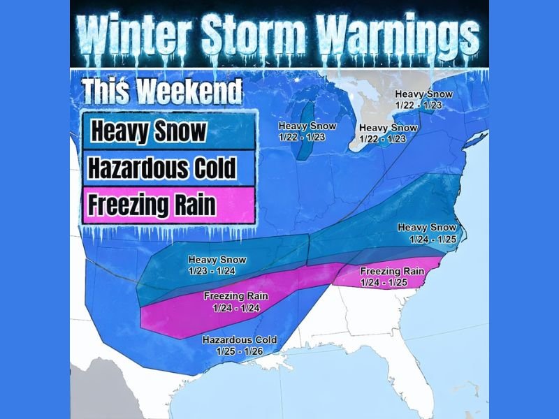
Major Late-Week Winter Storm Signals Heavy Snow, Freezing Rain, and Dangerous Cold From Texas to the Midwest and East
UNITED STATES — A high-impact winter storm is increasingly likely toward the end of this week, with forecast data showing a broad swath of heavy snow, significant freezing rain, and hazardous cold stretching from Texas through the Lower Midwest and into parts of the Eastern U.S. As models continue to fine-tune, confidence is growing that this will be one of the more dangerous winter setups of the season, especially where ice develops beneath accumulating snow.
A strong blocking high to the north is expected to force this system eastward, creating a classic ice-on-the-bottom, snow-on-top scenario that often leads to widespread travel issues and infrastructure stress.
Heavy Snow Zone Expands From the Plains Into the Midwest
Forecast guidance highlights multiple rounds of heavy snow developing as the storm evolves. Snow is expected to begin across parts of the Central Plains, then expand northeastward into the Midwest and Great Lakes, where prolonged snowfall over several days could lead to significant accumulations.
Key takeaways from the snow setup:
- Heavy snow is likely in multiple waves, not just a single burst
- Cold air locked in place supports efficient snow production
- Travel disruptions are likely, especially where snow overlaps with earlier icing
Freezing Rain and Ice a Major Concern in the South and Southeast
One of the most dangerous aspects of this storm is the freezing rain corridor, expected to develop from Texas eastward through the Deep South and toward the Carolinas. Forecast maps show a wide zone of freezing rain late in the week, coinciding with surface temperatures at or below freezing while warmer air rides overhead.
This setup raises concerns for:
- Ice accumulation on roads, bridges, and power lines
- Tree damage and power outages
- Extremely slick travel conditions, even where snowfall totals remain low
Hazardous Cold Follows the Storm
Behind the system, hazardous cold air is expected to surge southward, especially into Texas and parts of the South. This cold blast could linger into early next week, compounding impacts by freezing untreated roads and prolonging icy conditions.
Cold risks include:
- Refreezing of melted snow and ice
- Strain on heating systems
- Dangerous wind chills in exposed areas
Why This Pattern Is Especially Concerning
This is not a fast-moving storm. Instead, a blocking pattern slows the system, allowing impacts to last several days and overlap in dangerous ways. Even small shifts in the storm track could dramatically change who sees heavy snow versus crippling ice, making continued monitoring essential.
Bottom Line
A potentially severe winter storm late this week could impact a large portion of the country, bringing heavy snow, freezing rain, and dangerous cold from Texas through the Midwest and into the East. With ice beneath snow in some areas, impacts could escalate quickly. While details will continue to evolve, this is a storm worth preparing for now, especially in regions prone to icing.
Are winter warnings being discussed where you live? Share your local outlook and stay informed with ongoing updates from NapervilleLocal.com as this high-impact winter pattern continues to take shape.

I’ve lived in Naperville long enough to see how quickly our community changes — from new developments downtown to sudden shifts in our Midwest weather. Reporting on Naperville news and daily forecasts gives me the chance to keep neighbors informed about what really matters. My goal is simple: deliver clear, timely updates so you always know what’s happening in our city and what to expect from the skies above.