
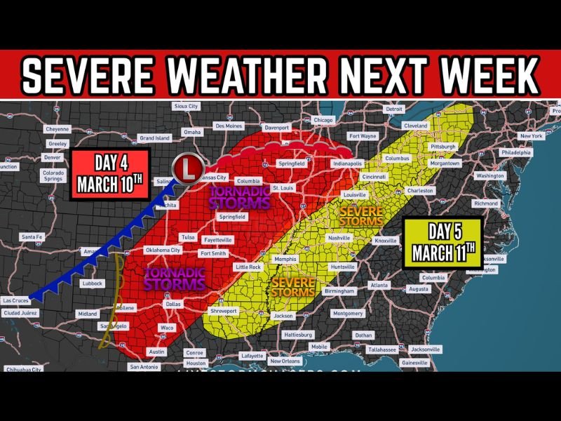
Major Severe Weather Threat Forecast for Texas, Oklahoma, Missouri, Illinois, and Indiana Tuesday–Wednesday With Tornadic Storms Possible
UNITED STATES — Meteorologists are closely watching the potential for a significant severe weather outbreak early next week as a powerful storm system moves across the central United States. Forecast models indicate that widespread severe thunderstorms, including possible tornado-producing storms, could develop Tuesday and Wednesday across a large portion of the country.
The system is expected to stretch from Texas and Oklahoma through Missouri and Illinois and into Indiana and parts of the Ohio Valley, placing millions of residents within the potential impact zone.
Tornadic Storms Possible Across the Southern Plains and Midwest
Early forecast projections show the greatest risk for tornadic supercells across Texas, Oklahoma, Arkansas, Missouri, and Illinois as the storm system strengthens across the Plains and Midwest.
Cities including Dallas, Oklahoma City, Tulsa, Springfield, St. Louis, and Little Rock are currently located within areas where conditions could support tornado-producing thunderstorms if the atmosphere becomes sufficiently unstable.
Meteorologists say the combination of warm Gulf moisture, strong upper-level winds, and an advancing cold front could create an environment favorable for severe weather development.
Severe Storms Could Spread Into the Ohio Valley
As the system progresses eastward, severe thunderstorms could extend farther into the Ohio Valley and parts of the eastern United States, including areas near Louisville, Cincinnati, Indianapolis, Columbus, and Pittsburgh.
In these regions, the primary threats may include damaging wind gusts, large hail, and isolated tornadoes depending on how the storm system evolves.
Forecast models currently highlight a broad corridor of severe weather potential stretching across several states.
Tuesday and Wednesday Identified as Key Risk Days
Meteorologists are currently highlighting Tuesday, March 10, and Wednesday, March 11 as the most likely timeframe for the severe weather threat.
On Tuesday, the strongest storms may develop across the southern Plains and central Midwest, particularly from Texas through Missouri and Illinois.
By Wednesday, the severe weather risk could shift farther east into the Ohio Valley and portions of the eastern United States.
Forecast Details Still Developing
Weather experts caution that specific details regarding the exact locations of the highest risk will become clearer in the coming days as new forecast data becomes available.
While it is still several days away, the early setup suggests the possibility of widespread thunderstorms across a large portion of the country, with some storms potentially becoming severe.
Residents across the Plains, Midwest, and Ohio Valley are encouraged to monitor forecast updates closely as meteorologists continue to track the developing storm system ahead of next week.

I’ve lived in Naperville long enough to see how quickly our community changes — from new developments downtown to sudden shifts in our Midwest weather. Reporting on Naperville news and daily forecasts gives me the chance to keep neighbors informed about what really matters. My goal is simple: deliver clear, timely updates so you always know what’s happening in our city and what to expect from the skies above.