
Major Sudden Stratospheric Warming Event May Disrupt the Polar Vortex, Potentially Triggering Significant U.S. Cold Outbreaks in Early December
UNITED STATES — Meteorologists are closely watching a developing Sudden Stratospheric Warming (SSW) event that could disrupt the polar vortex high above the Arctic, potentially sending frigid Arctic air southward into the United States in the early days of December. Forecast data shows temperatures in parts of the Arctic stratosphere may warm 40–60°F above normal, weakening the tight circulation that typically keeps icy air locked near the pole.
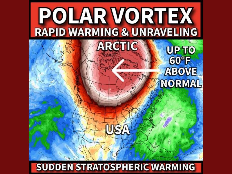
What Exactly Is About to Happen to the Polar Vortex?
The polar vortex being discussed is not the one at ground level. Forecasters are referring to the stratospheric polar vortex—a wind circulation system that sits around 12 miles above Earth, far above typical weather patterns.
This system is projected to experience a rapid warming of more than 50 degrees in the coming days. When this happens, the vortex can weaken, stretch, or even split, leading to:
- Breakdown of the vortex’s cold-air containment
- Disruption of the jet stream
- Possible surges of Arctic air into the mid-latitudes
These effects typically appear 1–2 weeks after the warming event, placing potential U.S. impacts in early December.
Meteorologists emphasize that the science behind SSW events is well-studied, and while the impacts vary, such disruptions often lead to extreme cold outbreaks, especially across the central and eastern United States.
Why This Event Could Be More Significant Than Usual
This particular warming event coincides with a range of additional cold-weather climate signals, including influences from:
- La Niña
- The Madden–Julian Oscillation (MJO)
- The Arctic Oscillation (AO)
When multiple cold-enhancing climate patterns line up, they can reinforce each other, increasing the probability of:
- Stronger cold fronts
- Extended Arctic outbreaks
- Below-normal temperatures for large portions of the country
Some long-range projections even suggest this combination could produce one of the colder early Decembers in recent years, though meteorologists caution that no outcome is guaranteed at this stage.
How Far South Could the Cold Reach?
The potential path of the cold air remains highly uncertain, and details will not fully clarify for at least another week. However, preliminary scenarios show Arctic air could reach:
- The Midwest and Great Lakes
- The central U.S.
- Portions of the South
- Possibly even areas near the Gulf Coast, depending on the jet stream pattern
Whether states like Florida experience any impact remains unclear, but forecasters say the jet stream’s position will determine which regions get the brunt of the cold.
The situation is fluid, and meteorologists are urging the public to follow updates closely as model clarity improves.
If you want continuing updates on the polar vortex disruption, long-range winter forecasts, and early-December cold risks, stay connected with NapervilleLocal.com for the latest weather insights.

I’ve lived in Naperville long enough to see how quickly our community changes — from new developments downtown to sudden shifts in our Midwest weather. Reporting on Naperville news and daily forecasts gives me the chance to keep neighbors informed about what really matters. My goal is simple: deliver clear, timely updates so you always know what’s happening in our city and what to expect from the skies above.