
Major Winter Blast to Sweep Across the U.S. With Blizzard Conditions, Ice Storms, and Tornado Threats Before Cold Air Reaches Florida
FLORIDA — A powerful multi-hazard winter system is sweeping across the country, delivering blizzard conditions in the Upper Midwest, an ice storm in the Northeast, and tornado threats stretching through the Ohio River Valley. Forecasters warn that this dangerous pattern is being driven by a surge of Arctic air plunging southward, creating extreme weather contrasts from the central U.S. to the East Coast.
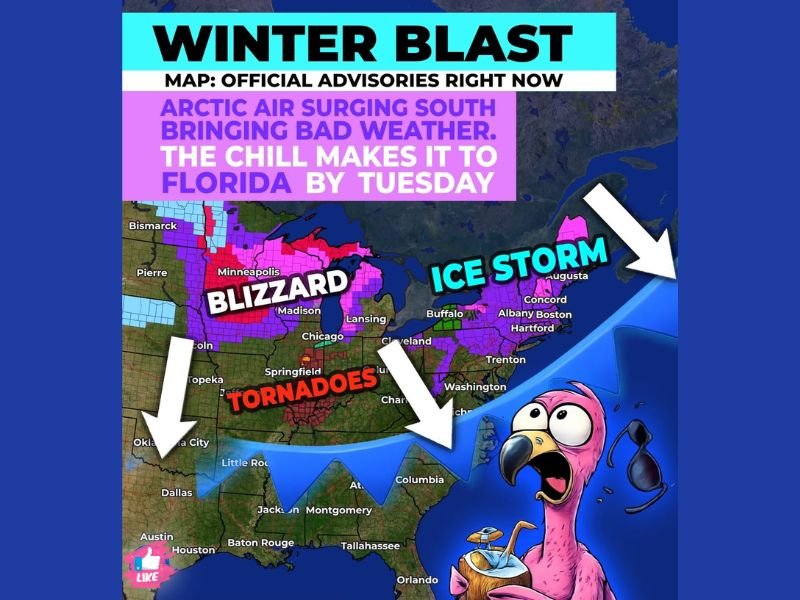
According to the weather map provided, widespread winter advisories, blizzard warnings, and ice storm alerts are already in effect. The system’s reach has expanded rapidly, with impacts expected to continue through early this week as the cold air advances south.
Blizzard Sweeps Through the Upper Midwest
The storm is producing blizzard conditions across states including Minnesota, Wisconsin, Iowa, and portions of the Dakotas. Strong winds combined with heavy snowfall are creating whiteout visibility, dangerous travel conditions, and rapidly drifting snow.
Cities such as Minneapolis and Chicago lie on the edge of this powerful winter zone, where snowfall rates and wind intensity may vary but still contribute to hazardous commutes. Forecasters urge residents to avoid travel during peak blizzard hours, as blowing snow may cause near-zero visibility in open areas. The widespread purple and red shading on the map indicates severe winter alerts covering a broad section of the northern U.S., emphasizing the magnitude of this storm.
Ice Storm Threat Expands Across the Northeast
To the east, the same cold system is fueling a significant ice storm threat across parts of New England and the interior Northeast. Areas including Boston, Hartford, Albany, and Burlington may see extended periods of freezing rain, potentially leading to widespread icing on roads, trees, and power lines.
Ice accumulations as shown on the map could result in scattered power outages and treacherous travel conditions. Freezing rain combined with cold surface temperatures often creates a thicker layer of ice, making even short trips hazardous. Residents in these regions should prepare for potential disruptions as the storm continues strengthening into Monday.
Tornadoes Possible in the Ohio River Valley
The sharp contrast between cold Arctic air and warmer southern air is triggering severe thunderstorms and tornado risks through parts of the Ohio River Valley. This includes states such as Indiana, Kentucky, Ohio, and Tennessee.
The severe weather zone on the map highlights areas where rotating storms may develop quickly. While winter systems often bring heavy snow and ice, this particular setup allows for a corridor of instability to form ahead of the advancing cold front, increasing the risk of damaging storms and isolated tornadoes. Forecasters recommend staying alert for rapidly changing conditions and possible warnings.
Cold Air Surges South, Reaching Florida by Tuesday
One of the most striking features of this system is how far south the Arctic air is expected to travel. The forecast graphic shows the cold surge pushing all the way into Florida by Tuesday, promising an unusually chilly start to the New Year for the Southeast.
Temperatures across the Deep South will drop sharply as the front arrives, with colder-than-normal mornings extending into midweek. While Florida will not see snow, the arrival of Arctic air may create unusually cool conditions for early January.
As this massive winter system continues its cross-country impact, NapervilleLocal.com will track the blizzard alerts, ice storm developments, and severe weather threats while monitoring how far the Arctic air spreads. Check back for the latest updates, forecast adjustments, and nationwide winter coverage as conditions evolve.

I’ve lived in Naperville long enough to see how quickly our community changes — from new developments downtown to sudden shifts in our Midwest weather. Reporting on Naperville news and daily forecasts gives me the chance to keep neighbors informed about what really matters. My goal is simple: deliver clear, timely updates so you always know what’s happening in our city and what to expect from the skies above.