
Major Winter Storm Could Slam Michigan Sunday Into Monday With Heavy Snow, Ice Storm Threat, and Blizzard Conditions
MICHIGAN — Forecasters are warning that a significant winter storm could impact Michigan Sunday into Monday, bringing a dangerous mix of heavy snow, icing, strong winds, and possible blizzard conditions across parts of the state.
Meteorologists say confidence is increasing that this storm could become one of the most impactful winter systems the region has seen in some time, with multiple hazards expected depending on location.
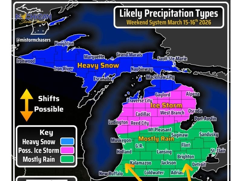
Heavy Snow Likely Across the Upper Peninsula
The northern portion of Michigan is expected to see the most intense snowfall. Forecast projections show more than a foot of snow possible across parts of the Upper Peninsula, particularly in areas including:
- Houghton
- Ironwood
- Marquette
- Escanaba
- Grand Marais
- Sault Ste. Marie
These regions are likely to remain on the cold side of the storm, allowing snow to accumulate quickly as the system strengthens. Strong winds combined with heavy snowfall could create dangerous travel conditions and reduced visibility.
Ice Storm Threat Across Northern Lower Michigan
A large portion of northern Lower Michigan could instead face a different but equally dangerous hazard: freezing rain and ice accumulation.
Communities including Gaylord, Alpena, West Branch, Cadillac, Reed City, and Oscoda fall within the potential ice storm zone. Ice accumulation in these areas could create hazardous travel conditions and place stress on the power grid, potentially leading to power outages if ice builds up on trees and power lines.
Mostly Rain Expected in Southern Michigan
Farther south, temperatures may remain warm enough for mainly rain rather than snow or ice. Cities including Grand Rapids, Lansing, Flint, Detroit, Brighton, Kalamazoo, Jackson, and Adrian are currently projected to experience primarily rainfall during the storm.
However, meteorologists caution that the system could begin or end with mixed precipitation, meaning some areas may briefly see sleet or freezing rain during the transition periods.
Strong Winds Could Create Blizzard Conditions
In addition to snow and ice, the storm is expected to produce powerful wind gusts that could exceed 45 mph. These winds could create blizzard conditions across northern Michigan, especially in areas receiving heavy snowfall where blowing snow could significantly reduce visibility. Wind-driven snow may also lead to dangerous travel conditions and drifting across roadways.
Forecast Details May Still Shift
Meteorologists stress that exact precipitation zones could shift as the storm system develops over the coming days. Small changes in storm track or temperature profiles could shift the heavy snow, ice, and rain zones north or south across the state.
Forecasters plan to release more detailed snowfall, ice accumulation, and wind forecast maps later today as confidence in the storm track continues to increase. Residents across Michigan are encouraged to begin preparing now for possible significant winter weather impacts Sunday through Monday, particularly in areas expected to see heavy snow or ice.

I’ve lived in Naperville long enough to see how quickly our community changes — from new developments downtown to sudden shifts in our Midwest weather. Reporting on Naperville news and daily forecasts gives me the chance to keep neighbors informed about what really matters. My goal is simple: deliver clear, timely updates so you always know what’s happening in our city and what to expect from the skies above.