
Major Winter Storm Expected Friday With Heavy Snow Targeting Eastern Pennsylvania and New Jersey, Forecasters Warn
United States — A significant winter storm is gaining strength and is expected to deliver heavy snowfall to Eastern Pennsylvania and New Jersey on Friday, according to newly released model data. Forecast images highlight a sharply defined bullseye over the region, where snow totals could become substantial as the system intensifies.
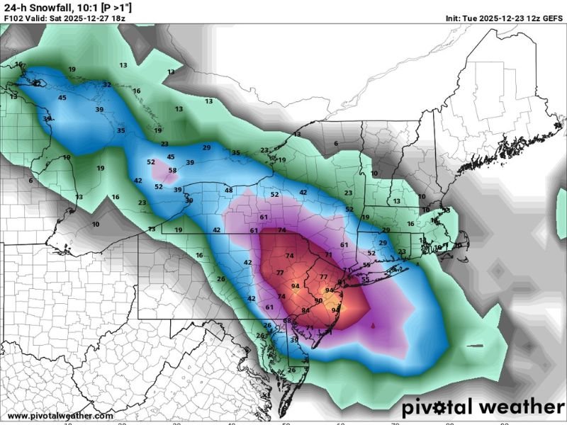
Storm Models Highlight High-Impact Zone Over Eastern Pennsylvania and New Jersey
The latest snowfall projection map shows a concentrated zone of intense accumulation centered directly over eastern portions of Pennsylvania and much of New Jersey. Color shading on the model output displays deep red and purple values, indicating the highest snow potential within the storm’s core.
These readings — some exceeding 70 to 90 units on the model scale — reflect the likelihood of a high-impact winter event capable of producing disruptive amounts of snow. Surrounding regions, including parts of New York, Maryland, and northern Virginia, show lower but still notable accumulation potential on the system’s outer edges.
Forecasters note that the storm’s trajectory and atmospheric setup support strong uplift and steady moisture flow, two key ingredients needed for heavy snowfall.
Forecasters Expect “Healthy Totals” as System Approaches
Accompanying the data, meteorologists emphasized that “healthy totals” are possible with this storm, underscoring the potential severity for communities within the highlighted impact area.
The storm is projected to approach the region late Thursday into early Friday, with snowfall becoming widespread by the afternoon. As colder air deepens across the mid-Atlantic, precipitation is expected to fall primarily as snow throughout the event.
Residents in Eastern Pennsylvania — including areas around Allentown, Reading, and Philadelphia — as well as central and northern New Jersey may experience the most intense snowfall, along with hazardous travel and reduced visibility.
Timing and Expected Impacts
While the precise totals may shift as the system evolves, current model trends suggest:
- Snow beginning Friday morning or early afternoon
- Peak intensity occurring during the late afternoon and evening
- Heavy bands capable of producing rapid accumulation
- Risk of travel disruptions on interstates and major urban corridors
- Potential delays or cancellations for regional air travel
With the projected snowfall amounts, road conditions may deteriorate quickly once heavier bands develop. The greatest travel concerns appear focused around major metro areas such as Philadelphia, Trenton, and Newark.
Forecast Confidence Increasing as Storm Nears
As of the latest update, confidence continues to grow in the location and strength of this winter storm. Snowfall projections have remained consistent across successive model runs, a sign that the forecast scenario is stabilizing.
Even so, meteorologists urge residents in Eastern Pennsylvania and New Jersey to monitor additional updates, as small shifts in the storm’s track could alter local snowfall totals. The overall message remains clear: a high-impact winter event is increasingly likely for the region on Friday.
Stay Updated With Reliable Weather Coverage
With winter storms developing rapidly across the country, staying informed is essential. NapervilleLocal.com will continue monitoring national weather patterns and providing updates as this system approaches. For more weather alerts, storm tracking, and travel-impact coverage, visit NapervilleLocal.com.

I’ve lived in Naperville long enough to see how quickly our community changes — from new developments downtown to sudden shifts in our Midwest weather. Reporting on Naperville news and daily forecasts gives me the chance to keep neighbors informed about what really matters. My goal is simple: deliver clear, timely updates so you always know what’s happening in our city and what to expect from the skies above.