
Major Winter Storm to Bring Up to a Foot of Snow Across Northern and Central Utah on Sunday, Impacting Travel and Boosting Ski Resorts
UTAH — A powerful early-winter storm is on track to hit Utah on Sunday, bringing moderate to heavy snowfall across northern and central portions of the state. Forecasters warn that travel could become hazardous in mountain areas while ski resorts prepare for a much-needed blanket of fresh snow.
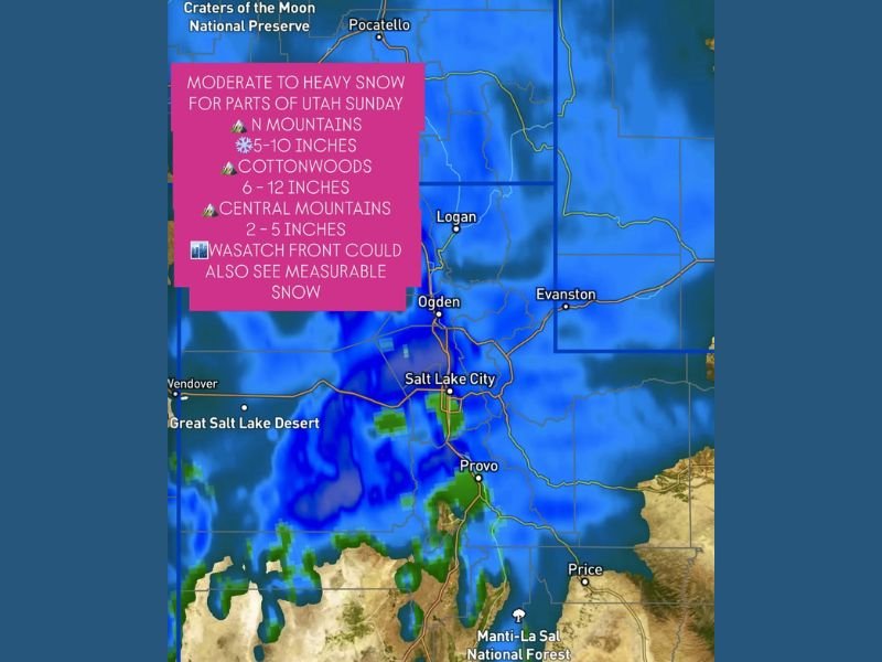
The system, moving southeast from the Pacific Northwest, will intensify as it reaches Utah, placing areas from Logan to Provo and through the Wasatch and Central Mountains in the path of accumulating snow.
Widespread Heavy Snow Expected Across Utah’s Mountains
Meteorologists say the northern mountains could see 5–10 inches of accumulation, while the Cottonwood Canyons — including Snowbird and Alta — could see 6–12 inches or more as northwest winds funnel moisture into the higher terrain.
Meanwhile, the Central Mountains are expected to receive 2–5 inches, adding to the snowpack that’s been slow to build this season. Even the Wasatch Front, including Salt Lake City, could see light snow or flurries, especially along the east benches where temperatures will remain slightly colder.
“This storm will be very beneficial for the ski areas,” forecasters said, noting that the northwesterly flow pattern is ideal for heavy snow in the Cottonwoods and northern mountain zones.
Travel Conditions Likely to Deteriorate
Snow will begin late Saturday night and intensify through Sunday morning and afternoon, continuing into early Monday before tapering off.
Travel impacts are expected along I-80, I-15, and U.S. 89, especially through Parleys Canyon, Sardine Canyon, and Logan Canyon, where slick roads and reduced visibility are likely.
Residents and holiday travelers are urged to avoid unnecessary travel during peak snow hours and to prepare vehicles for winter driving conditions.
Regional Snowfall Forecast
- Northern Mountains (Ogden, Logan, Evanston): 5–10 inches
- Cottonwoods (Alta, Snowbird, Brighton): 6–12 inches, locally higher
- Central Mountains (Provo to Price corridor): 2–5 inches
- Wasatch Front (Salt Lake City metro): Trace to 2 inches, mainly on east benches
A Boost for Ski Resorts and Water Supply
The incoming storm is excellent news for Utah’s ski industry and snowpack levels, both of which have lagged behind average this season.
“This system will help jump-start winter recreation and contribute to the state’s water supply heading into December,” meteorologists added.
While the storm will bring travel disruptions, it’s a welcome sight for skiers and snowboarders hoping to hit the slopes as December begins.
For continuing updates on Utah’s winter weather and travel advisories, visit NapervilleLocal.com for the latest community alerts and regional coverage.

I’ve lived in Naperville long enough to see how quickly our community changes — from new developments downtown to sudden shifts in our Midwest weather. Reporting on Naperville news and daily forecasts gives me the chance to keep neighbors informed about what really matters. My goal is simple: deliver clear, timely updates so you always know what’s happening in our city and what to expect from the skies above.