
Major Winter Storm to Slam California From Sunday Night Through Thursday With 4–8 Feet of Mountain Snow, 100 MPH Winds, Flooding and Tornado Threat
Sacramento, California — A major winter storm is set to unfold across California beginning Sunday night, bringing a dangerous combination of feet of mountain snow, 60–100 mph wind gusts, flooding concerns, and even a tornado risk in parts of the state. Forecasters warn that impacts will be felt statewide through at least midweek, with conditions deteriorating rapidly as the system strengthens.
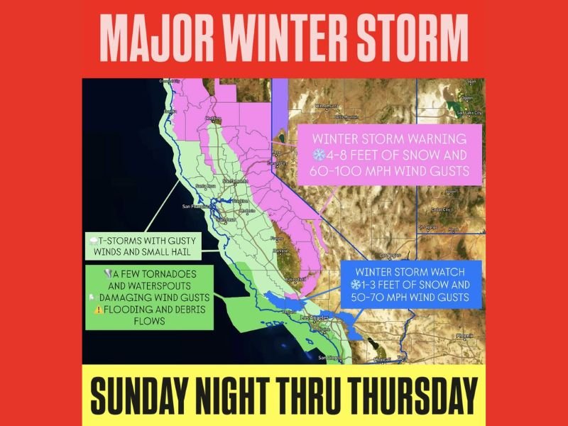
Mountain regions, including areas near Reno, Carson City, and the Sierra Nevada, are under a Winter Storm Warning for an extraordinary 4 to 8 feet of snow along with wind gusts between 60 and 100 mph. Lower elevations across interior Northern California are under a Winter Storm Watch, where 1 to 3 feet of snow and 50 to 70 mph gusts are possible.
Severe Weather Risk Across Coastal and Southern California
While the mountains brace for extreme snowfall, coastal and valley regions face a different set of hazards. From San Francisco south through San Jose, Fresno, and into Los Angeles and San Diego, strong thunderstorms are expected to bring gusty winds, small hail, and periods of heavy rain.
Meteorologists indicate that a few isolated tornadoes and waterspouts cannot be ruled out, particularly along coastal sections. The storm system’s dynamics support rotating thunderstorms capable of producing brief but intense wind damage. Urban corridors including Ventura, Bakersfield, and parts of Southern California could see rapidly changing conditions during peak storm periods.
Additionally, damaging wind gusts may cause scattered power outages and downed trees, especially where soils are saturated.
Flooding and Debris Flow Concerns Increase
Heavy rainfall over burn scar areas and steep terrain raises the risk of flash flooding and debris flows, particularly in foothill communities and canyon areas. Rapid runoff could overwhelm drainage systems in both Northern and Southern California.
With multiple waves of precipitation expected from Sunday night through Thursday, cumulative rainfall totals may exacerbate flooding concerns. Emergency management officials typically advise residents in vulnerable areas to prepare for possible evacuation notices and avoid travel during peak rainfall.
In the mountains, blizzard-like conditions may develop where heavy snow combines with high winds, creating near-zero visibility and dangerous travel across high passes.
This powerful system highlights California’s wide-ranging weather vulnerabilities — from coastal severe storms to historic mountain snowfall. Residents across the state are urged to monitor official forecasts and prepare for prolonged impacts through midweek. For continued national weather updates and in-depth storm coverage, visit NapervilleLocal.com for comprehensive reporting and analysis.

I’ve lived in Naperville long enough to see how quickly our community changes — from new developments downtown to sudden shifts in our Midwest weather. Reporting on Naperville news and daily forecasts gives me the chance to keep neighbors informed about what really matters. My goal is simple: deliver clear, timely updates so you always know what’s happening in our city and what to expect from the skies above.