
March 1–7 Severe Weather Signal Emerging Across the Deep South and Lower Mississippi Valley, Long-Range Models Flag Tornado and Wind Potential
UNITED STATES — Long-range forecast models are beginning to highlight a potentially active severe weather pattern setting up for the first week of March, with the strongest signal centered across the Deep South and Lower Mississippi Valley.
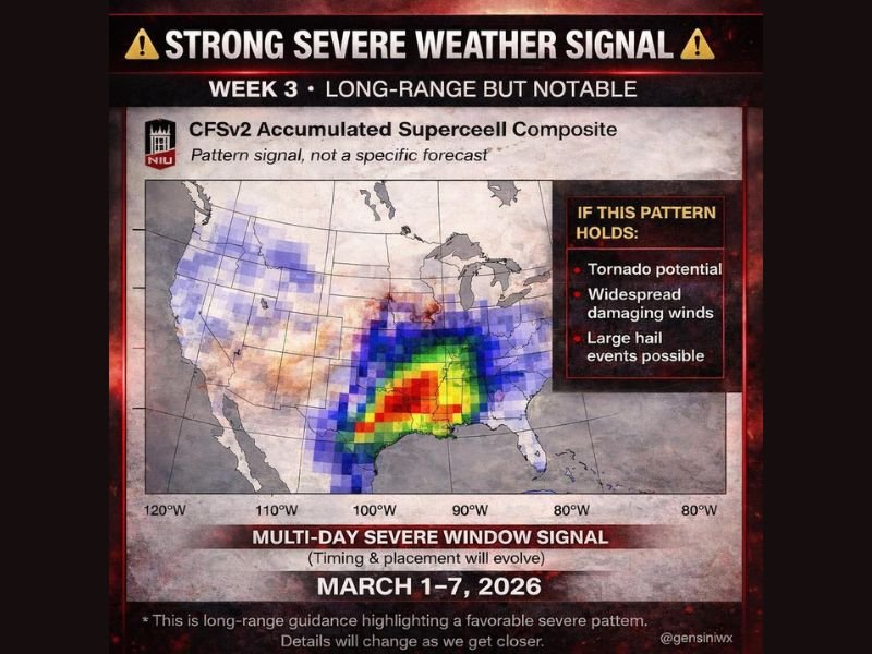
According to the latest CFSv2 accumulated supercell composite guidance, a multi-day severe window may develop between March 1 and March 7, with the most concentrated pattern signal stretching from eastern Texas through Louisiana, Mississippi, Alabama, and into parts of Arkansas and western Tennessee.
Forecasters stress that this is not a specific storm forecast, but rather a pattern-based signal indicating the atmosphere may become supportive of organized severe thunderstorms.
Where the Strongest Signal Is Located
The color-shaded map shows the most intense supercell signal across:
- East Texas
- Northern and central Louisiana
- Central and southern Mississippi
- Alabama
- Portions of Arkansas
The highlighted zone suggests that, if the pattern holds, conditions could support:
- Tornado potential
- Widespread damaging winds
- Large hail events
The model guidance labels this as a “multi-day severe window signal,” meaning the setup could allow for several rounds of storms rather than a single event.
Why Early March Can Turn Volatile
The first week of March often marks the seasonal transition when:
- Gulf moisture increases
- Jet stream energy remains strong
- Temperature contrasts sharpen
That combination frequently creates a favorable environment for organized thunderstorms across the South. While winter technically lingers on the calendar, early spring-style dynamics can begin emerging across the southern states. Meteorologists caution that timing, placement, and intensity details will evolve significantly as the period approaches.
What This Means for the Midwest
At this stage, the strongest signal remains south of Illinois. However, in active patterns, systems can track northward depending on how the jet stream shifts.
For now, the focus area remains concentrated across the Deep South corridor from Texas to Alabama. Illinois, including the Naperville area, is not currently within the highest signal zone for March 1–7. Still, early March pattern shifts are worth monitoring, especially as seasonal transitions accelerate.
Important Reminder About Long-Range Outlooks
Forecasters emphasize that this guidance highlights a favorable pattern — not a confirmed outbreak. Specific cities, dates, and storm modes will become clearer in the coming days.
Residents across the southern states should:
- Stay weather aware as March begins
- Monitor updated forecasts next week
- Review severe weather safety plans early
Pattern signals like this are designed as early awareness tools, not panic alerts.
As model data continues to refine, updates will clarify whether this signal strengthens, shifts, or weakens heading into the first week of March. For continued national weather outlooks and Midwest impact analysis, follow updates on NapervilleLocal.com.

I’ve lived in Naperville long enough to see how quickly our community changes — from new developments downtown to sudden shifts in our Midwest weather. Reporting on Naperville news and daily forecasts gives me the chance to keep neighbors informed about what really matters. My goal is simple: deliver clear, timely updates so you always know what’s happening in our city and what to expect from the skies above.