
Marginal Severe Storm Risk Expands Across Texas From Dallas–Fort Worth to Houston as Saturday System Strengthens
TEXAS — A slow-moving storm system is set to arrive early Saturday morning, bringing an increasing threat of showers and thunderstorms across much of the state. While the overall risk level remains classified as marginal, the strongest portion of the system is expected Saturday afternoon into early evening, when impacts could briefly intensify.
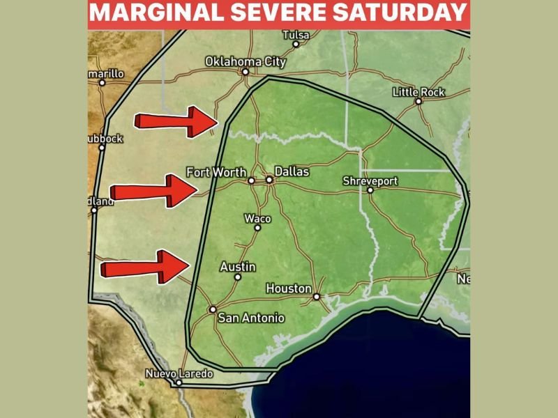
According to the forecast details shown, the storm coverage will increase through Saturday morning, with the main lift and energy peaking later in the day.
Areas Included in the Marginal Risk Zone
The outlined risk area covers a broad portion of Texas, including:
- Dallas
- Fort Worth
- Waco
- Austin
- Houston
- San Antonio
The risk zone also extends north toward the Oklahoma border and east toward the Louisiana line near Shreveport. Western cities such as Midland and Lubbock sit outside the primary green-shaded risk area shown on the map.
An additional note in the forecast mentions the potential for a slight upgrade in intensity along and east of a line from Sherman to McKinney to Corsicana, suggesting that storms in that corridor could briefly become stronger.
What to Expect Saturday
Forecasters indicate that:
- Showers and a few thunderstorms increase Saturday morning
- Strongest activity develops Saturday afternoon into early evening
- Wind gusts may reach up to 50 mph
- Small hail is possible
- Lightning and pockets of heavy rainfall are expected
The system may linger into Saturday evening, potentially affecting outdoor and Valentine’s plans before gradually shifting east. Some wraparound moisture on the backside of the system could briefly extend precipitation before it exits the region.
Timing and Outlook Beyond the Weekend
The system should clear the state by Sunday, bringing calmer conditions. However, another potential rain or storm chance is noted for next Saturday, continuing a roughly seven-day cycle pattern mentioned in the forecast.
While this is not expected to be a widespread severe outbreak, residents across central and eastern Texas — particularly from the Dallas–Fort Worth Metroplex southward toward Houston and San Antonio — should stay weather-aware during the afternoon and early evening hours Saturday.
For continuing updates on major weather systems affecting communities across the country, stay connected with NapervilleLocal.com.

I’ve lived in Naperville long enough to see how quickly our community changes — from new developments downtown to sudden shifts in our Midwest weather. Reporting on Naperville news and daily forecasts gives me the chance to keep neighbors informed about what really matters. My goal is simple: deliver clear, timely updates so you always know what’s happening in our city and what to expect from the skies above.