
Massive Dust Storm Sweeps Across West Texas, Creating Ominous Skies Near Ropesville
ROPESVILLE, TEXAS — Residents of Ropesville in West Texas witnessed an awe-inspiring and potentially dangerous weather event late Friday afternoon as a massive dust storm — locally known as a “haboob” — swept across the region, darkening the skies and creating near-zero visibility in some rural areas.
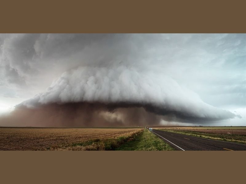
The storm rolled over the caprock region of West Texas, an area famous for its wide-open plains and unobstructed views of the horizon. The wall of dust appeared as a towering brown cloud surging beneath a shelf of low, rotating storm clouds — a sight that combined the raw beauty and danger of nature in one unforgettable moment.
The Power of the West Texas Plains
Photographers and storm chasers near Southeast Ropesville captured the dramatic scene on June 6, 2025, describing the storm as both mesmerizing and intimidating. One witness said the storm had a “certain presence that is felt,” likening it to a moment when “nature is coming at you, and you have to decide whether to observe, respect, or run.”
This region of West Texas, sitting atop the Llano Estacado, is known for being among the flattest expanses in North America. That vast, open terrain allows weather systems to form and travel unimpeded, turning the sky into a massive canvas for thunderstorms, dust storms, and spectacular lightning displays.
“You can see the sky for miles out here,” one observer wrote. “And when a beast like this appears, there’s nowhere to hide — just respect what you’re seeing.”
A Common West Texas Hazard
While scenes like this may appear cinematic, dust storms pose serious risks. These events can reduce visibility to a few feet, making driving hazardous. The Texas Department of Transportation (TxDOT) regularly urges drivers caught in such conditions to pull over, turn off headlights, and wait until the dust settles rather than attempting to drive through blinding winds.
Meteorologists explain that dust storms form when powerful downdrafts from thunderstorms push loose, dry soil and debris upward into the air. The result is a dense, fast-moving wall of dust that can stretch for miles, often preceding heavy rain or hail.
According to weather models, wind gusts in Friday’s storm exceeded 50 mph, with reports of brief power interruptions and blowing debris in parts of Hockley and Lubbock counties. No injuries were reported.
Nature’s Spectacle and Warning
For locals, dust storms are both a spectacle and a reminder of the harsh climate of the Texas plains. Farmers often prepare for these conditions by securing equipment and protecting livestock, while residents keep close watch on weather alerts during thunderstorm season.
Although Friday’s event did not cause significant damage, experts caution that increasing drought conditions across the southern plains could lead to more frequent dust storms this summer.
As one longtime resident summed up, “Out here, the land teaches you humility. You don’t control nature — you just learn to live with it.”
Stay updated on severe weather coverage and regional alerts at NapervilleLocal.com.

I’ve lived in Naperville long enough to see how quickly our community changes — from new developments downtown to sudden shifts in our Midwest weather. Reporting on Naperville news and daily forecasts gives me the chance to keep neighbors informed about what really matters. My goal is simple: deliver clear, timely updates so you always know what’s happening in our city and what to expect from the skies above.