
Massive Shelf Cloud Rolls Over Monroe, Louisiana, Turning the Sky Into a Dark Wall as Severe Storms Approach
LOUISIANA — Residents in Monroe watched the sky dramatically transform as a towering shelf cloud advanced over the city, creating a dark, wall-like formation that signaled severe weather was imminent.
The massive cloud structure rolled in thick and heavy, stretching across the horizon and swallowing daylight as it moved forward. Witnesses described the scene as one you could “feel before it hits” — the kind of atmosphere where winds shift, temperatures drop, and pressure builds just moments before a storm unleashes its force.
A Textbook Shelf Cloud Formation
The formation captured over Monroe is known as a shelf cloud, a low, horizontal cloud feature that forms along the leading edge of a strong thunderstorm or squall line. Shelf clouds are often associated with:
- Intense wind gusts
- Heavy rainfall
- Frequent lightning
- Rapid changes in visibility
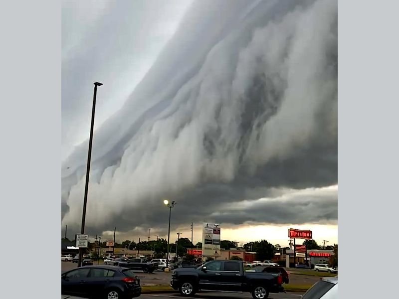
In photos shared from Monroe, the cloud appears layered and rolling, with a dramatic curved edge pushing outward. The lower portion hangs ominously over businesses and parking lots, while the upper layers arc skyward, giving the impression of a massive wall moving across the landscape.
What It Signals About the Storm
Shelf clouds themselves are not tornadoes, but they are powerful visual indicators that strong straight-line winds may follow. When formations build this aggressively, meteorologists often warn of potentially damaging wind gusts embedded within the storm.
The advancing structure over Monroe suggests a well-organized thunderstorm complex capable of producing sudden wind surges. These wind-driven storms can knock down tree limbs, cause isolated power outages, and create hazardous driving conditions within minutes.
Why These Storms Feel So Intense
Part of what makes a shelf cloud so dramatic is the atmospheric shift that precedes it. As the storm pushes forward, cooler air rapidly spreads outward along the ground, undercutting the warm, moist air ahead of it. That interaction creates the rolling, layered appearance visible in Monroe’s sky.
For many residents, the experience is as emotional as it is meteorological. The sky darkens quickly. Winds begin to whip through parking lots. Traffic slows as drivers try to gauge how quickly conditions may deteriorate.
Staying Weather Aware
While visually stunning, shelf clouds are a reminder to seek shelter and monitor updates when severe storms approach. Sudden wind gusts and heavy rain can make roads slick and reduce visibility almost instantly.
Weather watchers in Monroe captured a powerful example of how quickly conditions can shift in the Deep South. The scene serves as a clear reminder that when the sky starts to resemble a wall, it’s time to prepare. For continued severe weather coverage and breaking storm updates from across the country, stay connected with NapervilleLocal.com.

I’ve lived in Naperville long enough to see how quickly our community changes — from new developments downtown to sudden shifts in our Midwest weather. Reporting on Naperville news and daily forecasts gives me the chance to keep neighbors informed about what really matters. My goal is simple: deliver clear, timely updates so you always know what’s happening in our city and what to expect from the skies above.