
Michigan Braces for Dangerous Arctic Cold as Wind Chills Plunge to −30°F in Upper Peninsula and Near −10°F Across Lower Peninsula
MICHIGAN — A surge of Arctic air is set to bring life-threatening wind chills across Michigan, with conditions expected to bottom out late Sunday into Monday morning, according to forecast data. The cold will be intensified by gusty northwest winds, making it one of the harshest cold snaps of the season.
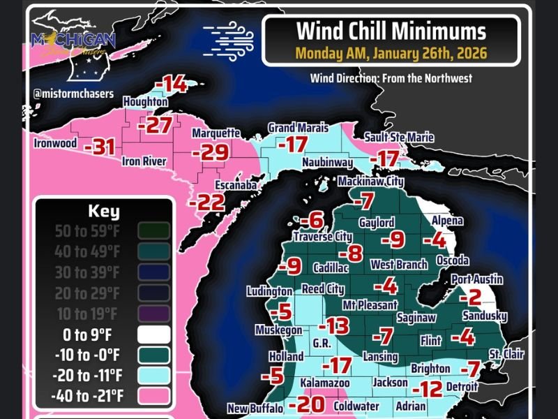
Wind chill values are forecast to reach −20°F to −30°F across much of the Upper Peninsula, while parts of the Lower Peninsula are expected to see wind chills near −10°F, particularly during the overnight and early morning hours.
Upper Peninsula Faces the Coldest Conditions
The most extreme cold is expected across the Upper Peninsula, where wind chills are forecast to drop into the −20°F to −30°F range. Some locations may experience even colder localized readings.
Cities and surrounding areas near Ironwood, Iron River, Marquette, Escanaba, and Houghton are among those facing the harshest conditions, with prolonged exposure posing a serious risk of frostbite in minutes.
Lower Peninsula Sees Widespread Subzero Wind Chills
Across the Lower Peninsula, wind chills are forecast to bottom out around −10°F, with several regions dropping even lower.
Forecast data shows:
• Detroit area near −12°F
• Lansing around −7°F
• Grand Rapids near −13°F
• Kalamazoo near −17°F
• Jackson near −7°F
• Traverse City around −6°F
Even areas closer to the lakes, including Muskegon and Holland, will experience dangerously cold wind chills, despite slightly moderated temperatures.
Northwest Winds Intensify the Cold
Winds are expected to blow primarily from the northwest, with gusts of 20 to 30 mph, significantly increasing the wind chill effect. These gusts will also generate lake-effect snow bands along Lake Michigan and Lake Superior.
While areas directly under lake-effect bands may experience slightly higher overnight temperatures, travel conditions can deteriorate quickly due to blowing snow and reduced visibility.
Cold Expected to Linger Into the New Week
Forecasters warn that this is not a short-lived cold blast. Arctic air is expected to remain in place into next week, keeping temperatures well below normal and increasing the risk of frozen pipes, vehicle issues, and prolonged exposure hazards.
Residents are urged to bundle up in multiple layers, limit time outdoors, ensure pets are protected, and check on vulnerable individuals. What are conditions like where you live as this Arctic cold settles in? Share your experience and stay updated with ongoing weather coverage at NapervilleLocal.com.

I’ve lived in Naperville long enough to see how quickly our community changes — from new developments downtown to sudden shifts in our Midwest weather. Reporting on Naperville news and daily forecasts gives me the chance to keep neighbors informed about what really matters. My goal is simple: deliver clear, timely updates so you always know what’s happening in our city and what to expect from the skies above.