
Michigan Braces for Foggy Start, Rain-to-Sleet Mix in Upper Peninsula, and 35+ MPH Wind Gusts Overnight
MICHIGAN — Conditions across the state are shifting quickly this Tuesday, February 17, 2026, as a developing low-pressure system moves in later tonight, bringing a mix of precipitation, strengthening winds, and even the possibility of thunder in southern areas.
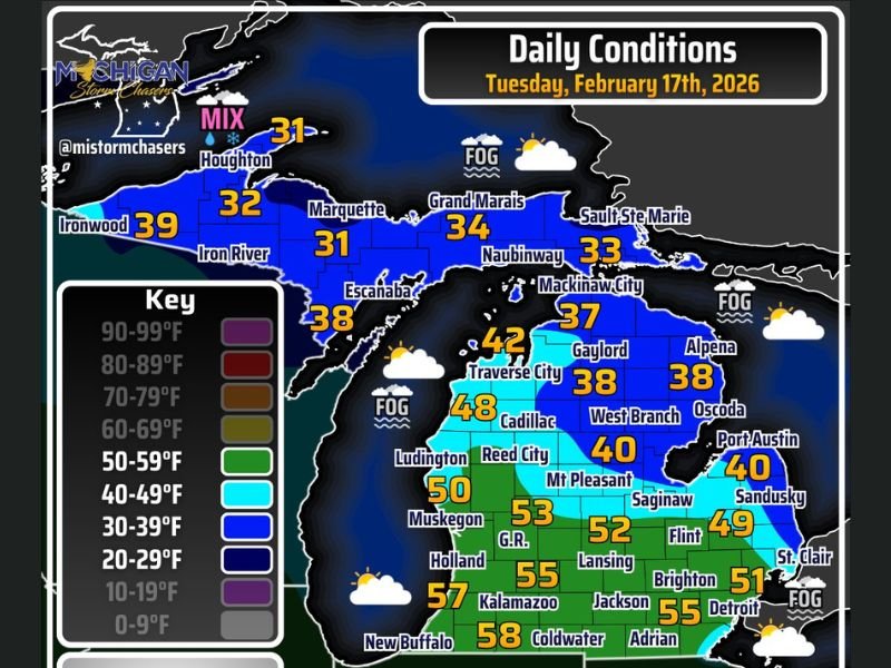
Morning hours are beginning on a quieter note, with areas of fog reported across parts of the state. Winds are relatively calm early, contributing to reduced visibility in some communities. As the day progresses, fog will gradually give way to partly to mostly cloudy skies statewide.
Temperatures today show a sharp divide between north and south. Southern Michigan is warming significantly, with highs climbing back into the 50s. Cities such as Kalamazoo (58°), Grand Rapids (53°), Detroit (55°), and Jackson (55°) are all seeing above-average readings for mid-February. Lansing is near 52°, while Muskegon reaches around 50°.
Farther north, however, it is a different story. Much of northern Michigan remains locked in the 30s and low 40s. Gaylord is near 38°, Alpena around 38°, West Branch near 40°, and Mackinaw City in the upper 30s. Across the Upper Peninsula, temperatures stay colder still — Marquette and Houghton hover near 31°, Iron River near 32°, and Escanaba in the upper 30s.
Rain and Sleet Arrive in the Western Upper Peninsula
By evening, the outer bands of the approaching low-pressure system will begin impacting the western Upper Peninsula. A mix of rain and sleet is expected initially in areas like Ironwood and Houghton before precipitation expands overnight.
As colder air deepens across northern Michigan and the U.P., all precipitation types — including rain, sleet, and snow — are expected to fill in across the remainder of the state. The Upper Peninsula will likely see the most significant travel concerns first.
Forecasters indicate that broader travel impacts are more likely to begin Wednesday morning, primarily across northern Michigan, as precipitation becomes steadier and temperatures remain near or below freezing.
Winds Increase, Thunder Possible in Southern Michigan
Winds will steadily increase through the evening hours. While calm conditions dominate early Tuesday due to fog, gusts later tonight may exceed 35 mph in parts of the state. These strengthening winds could reduce visibility further in areas of precipitation and create choppy conditions near the Great Lakes shorelines.
In southern Michigan, where temperatures remain in the 50s today, enough instability could develop for a few rumbles of thunder overnight — potentially as early as 2 to 4 a.m. Though widespread severe weather is not expected, brief downpours and gusty winds could accompany stronger cells.
What to Expect into Wednesday
The system continues to push across Michigan through Wednesday morning. Northern portions of the Lower Peninsula and the Upper Peninsula will see the greatest risk for slick roads and wintry travel impacts.
Southern Michigan, including Detroit, Ann Arbor, and Kalamazoo, will transition through periods of rain overnight before temperatures begin cooling behind the system.
The key weather concerns statewide include:
- Morning fog reducing visibility early Tuesday
- A rain/sleet mix developing in the western U.P. this evening
- Expanding precipitation overnight
- Wind gusts exceeding 35 mph
- Possible isolated thunder in southern Michigan
Residents are encouraged to monitor local forecasts closely as conditions evolve through the night and into Wednesday morning. For continued updates on major weather systems across the Midwest and Great Lakes, stay connected with NapervilleLocal.com.

I’ve lived in Naperville long enough to see how quickly our community changes — from new developments downtown to sudden shifts in our Midwest weather. Reporting on Naperville news and daily forecasts gives me the chance to keep neighbors informed about what really matters. My goal is simple: deliver clear, timely updates so you always know what’s happening in our city and what to expect from the skies above.