
Michigan, Indiana, Ohio and Pennsylvania Face Growing Severe Storm Threat Thursday as Forecast Highlights Midwest Risk Zone
SOUTHERN MICHIGAN — A new forecast outlook is pointing to a developing risk of strong to severe storms across parts of the Midwest on Thursday, with southern Michigan emerging as one of the key areas to watch.
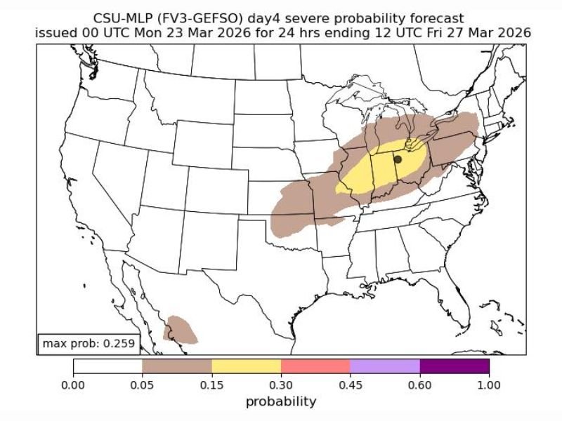
The latest probability-based model highlights a concentrated zone of concern stretching across Michigan, Indiana, Ohio, and into Pennsylvania, signaling a potential for impactful weather as the system develops later this week.
Midwest Risk Zone Expands Across Multiple States
The forecast map shows a broad area of elevated storm potential covering portions of the central and eastern Midwest. The most notable zone includes southern Michigan, where the model suggests a higher likelihood of severe weather compared to surrounding regions.
This risk area extends southwest into Indiana and parts of Illinois and Kentucky, while also pushing eastward through Ohio and into Pennsylvania, forming a corridor of concern across several states.
What the Forecast Model Indicates
According to the probability outlook, the highest concentration of severe weather potential sits within a highlighted region centered over parts of southern Michigan and nearby states.
While the maximum probability values remain moderate, the setup suggests conditions could support organized storms capable of producing strong winds, heavy rain, and possibly isolated severe impacts.
This type of model guidance is often used to identify early signals of severe weather potential several days in advance, allowing time for closer monitoring as the event approaches.
Timing Focused on Thursday Development
The current outlook specifically targets Thursday as the primary window for storm development. Atmospheric conditions during this period may become favorable for storm formation across the highlighted Midwest corridor.
Forecast updates are expected to refine the exact timing, intensity, and coverage of storms as newer data becomes available.
Why Southern Michigan Stands Out
Southern Michigan is specifically noted in the forecast as an area where severe storm potential may be more pronounced. Its position within the broader risk zone places it near the center of the developing system. This increases the likelihood that storms forming in surrounding states could track into or intensify over this region.
What Happens Next
Officials and weather watchers are expected to closely monitor updates over the next 24 to 48 hours, with more detailed forecasts anticipated soon. An updated first-call forecast is expected to be released, which will provide a clearer picture of storm timing and potential impacts across the region.
Residents across Michigan, Indiana, Ohio, and Pennsylvania should remain aware of changing conditions as Thursday approaches, especially in areas currently highlighted within the risk zone. Stay with NapervilleLocal.com for continued updates as this developing Midwest storm threat becomes clearer and more detailed.

I’ve lived in Naperville long enough to see how quickly our community changes — from new developments downtown to sudden shifts in our Midwest weather. Reporting on Naperville news and daily forecasts gives me the chance to keep neighbors informed about what really matters. My goal is simple: deliver clear, timely updates so you always know what’s happening in our city and what to expect from the skies above.