
Michigan Low-Pressure System Pushes Organized Rain and Snow Across New York, Pennsylvania, Massachusetts and Maine
Northeast United States — A broad area of organized precipitation continues moving across the region this morning, with much of the steady rain and snow already shifting into Maine while additional showers remain poised to move in from the west.
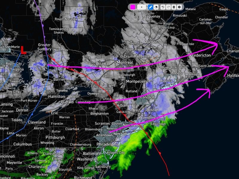
A 9:30 a.m. radar update shows the majority of the organized band either exiting southern New England or pushing northward into Maine. However, lingering batches of precipitation remain over parts of New York, Pennsylvania, and the eastern Great Lakes, indicating the system is not yet finished.
Low-Pressure System Anchors the Activity
Radar imagery highlights a defined low-pressure system over Michigan and the Upper Great Lakes, marked by a red “L” near northern Michigan . This low is driving the structured, west-to-east flow of precipitation across the Northeast.
From Buffalo and Albany, New York, to Boston, Massachusetts, and Portland, Maine, precipitation appears in a coherent band aligned with the storm track. Snow is visible across interior sections of upstate New York, Vermont, New Hampshire, and western Maine, while rain dominates farther south near New York City and coastal Massachusetts.
The organized structure of the precipitation indicates that it is tied directly to the broader circulation of the low-pressure system rather than forming randomly.
Organized vs. Disorganized Showers
Meteorologists often distinguish between organized and disorganized precipitation patterns. Organized showers, like those currently moving through New York, Pennsylvania, Massachusetts, and Maine, are associated with a defined storm system that maintains structure and continuity as it travels.
In this case, the low-pressure center is providing enough lift and atmospheric support to sustain precipitation across multiple states. While the system may not be intense enough to qualify as a major storm, it remains capable of producing steady precipitation as it progresses eastward.
By contrast, disorganized showers — such as pop-up rain or lake-effect snow — typically develop without a centralized low-pressure system. Those showers tend to be more scattered and short-lived, often riding upper-level winds without a clearly defined surface circulation.
The current radar presentation clearly reflects an organized setup tied to the storm’s center over the Great Lakes .
What Comes Next
As the system continues its eastward progression, precipitation will gradually taper from west to east. Areas in western New York and Pennsylvania should see improving conditions first, while parts of Maine and eastern Massachusetts remain in the active zone longer.
Additional scattered showers may rotate through behind the main band, particularly in areas still influenced by wraparound moisture from the low. However, widespread heavy precipitation is not indicated at this time.
Residents across the Northeast should remain alert for slick travel conditions in areas experiencing snow or mixed precipitation. Visibility may fluctuate in heavier bursts, especially across interior higher elevations.
For continued updates on regional weather systems and radar developments across the United States, visit NapervilleLocal.com for detailed coverage and ongoing forecast analysis.

I’ve lived in Naperville long enough to see how quickly our community changes — from new developments downtown to sudden shifts in our Midwest weather. Reporting on Naperville news and daily forecasts gives me the chance to keep neighbors informed about what really matters. My goal is simple: deliver clear, timely updates so you always know what’s happening in our city and what to expect from the skies above.