
Michigan Showers and Thunder Move Through Grand Rapids and West Michigan While Northern Areas Deal With Wintry Mix Early Wednesday
MICHIGAN — A line of showers and embedded thunderstorms is pushing across western Lower Michigan early Wednesday morning, bringing steady rain and occasional rumbles of thunder to communities including Grand Rapids, Muskegon, and Kalamazoo, while northern parts of the state continue to see a messy mix of precipitation.
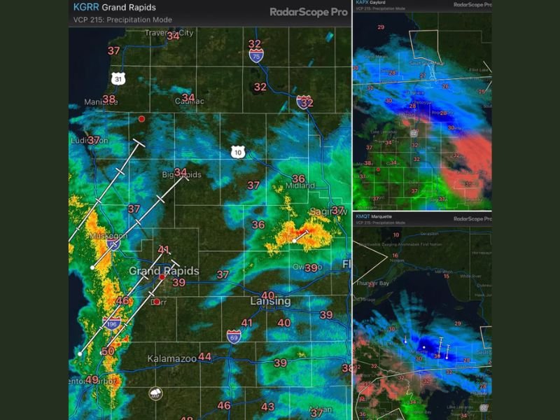
As of 6:02 a.m. on February 18, 2026, radar imagery shows the most organized band of rain stretching north to south along the Lake Michigan shoreline, advancing eastward.
West Michigan Wakes Up to Rain and Thunder
The heaviest rainfall early this morning is concentrated from near Benton Harbor and South Haven northward through Muskegon. Bright yellows and oranges on radar indicate moderate to heavy downpours embedded within the line.
Grand Rapids is seeing steady rainfall with temperatures around 39 degrees. Muskegon sits near 37 degrees, while Kalamazoo is warmer at 44 degrees. Farther south toward the state line, readings climb into the upper 40s. While no severe weather is expected, atmospheric instability is sufficient for a few thunderstorms. Residents across west Michigan should not be surprised to hear brief claps of thunder as the line continues moving inland.
Central Michigan Sees Steady Rain
As the rain progresses east, communities such as Big Rapids (34°), Midland (36°), Lansing (40°), and Owosso (39°) are seeing lighter to moderate rainfall. Temperatures across central Lower Michigan are generally in the mid-30s to near 40 degrees, which keeps precipitation primarily in liquid form. Roads may become wet and slick, particularly during heavier bursts of rain.
Northern Lower and Upper Michigan Face Mixed Precipitation
Farther north, the situation becomes more complicated.
In northern Lower Michigan, including Gaylord (32°), Petoskey (28°–32° range), and Alpena (upper 20s to low 30s), radar shows areas of mixed precipitation. This includes a blend of rain, sleet, and wet snow depending on exact location and surface temperatures.
In the Upper Peninsula, including Marquette (around 30°–32°), precipitation remains wintry in spots. Temperatures hovering near freezing are allowing for snow and sleet, especially across the western and central U.P. This mixed precipitation is expected to continue through the morning hours before gradually tapering or transitioning as temperatures shift.
No Severe Weather, But Travel Impacts Possible
Although thunderstorms are embedded within the western rain band, there is no indication of severe storms at this time. However, heavier rainfall could reduce visibility briefly during the morning commute in western Lower Michigan.
In northern areas, where temperatures sit closer to freezing, localized slick spots are possible due to mixed precipitation. Drivers across Michigan should monitor local conditions, especially in areas where precipitation type may vary over short distances.
What to Expect Through the Morning
The line of showers will continue tracking eastward across Lower Michigan through the morning. Thunder chances remain confined mainly to western and southwestern sections of the state.
Northern Michigan will likely hold onto the mixed precipitation scenario longer, with gradual improvement later in the day as the system progresses. For continued weather updates affecting Michigan and surrounding regions, stay connected with NapervilleLocal.com.

Naperville is a community with stories that deserve to be told — both the serious ones about safety and justice, and the lighter ones that capture our culture and daily life. I focus on covering crime reports and court updates while also highlighting the traditions, events, and social trends that shape who we are. Through my reporting, I want to give readers a fuller picture of Naperville — the challenges we face and the character that keeps our city strong.