
Michigan Snow and Ice Threat Targets Upper Peninsula Including Keweenaw Peninsula With Wintry Mix Before Midnight
UPPER PENINSULA, MICHIGAN — A late-season wintry system is sweeping across Michigan’s Upper Peninsula today, bringing a mix of snow and light icing that is expected to persist through the evening before tapering off prior to midnight.
Forecasters indicate that while this is not a major winter storm, it still carries enough impact to create slick travel conditions—especially in northernmost areas like the Keweenaw Peninsula and far northeastern sections of the Upper Peninsula.
Snowfall Focused Across Northern Upper Peninsula
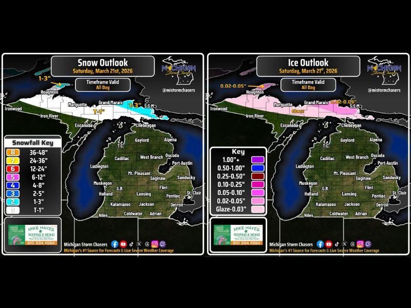
The primary concern today is light to moderate snowfall across northern counties. Areas including Houghton, Marquette, and Grand Marais are expected to see between 1 to 3 inches of snow through the day.
Localized bands could briefly intensify snowfall rates, particularly near Lake Superior shorelines, where lake-enhanced snow is possible. However, accumulations are expected to remain within manageable levels overall.
Southern parts of the Upper Peninsula, including Iron River and Escanaba, may see lighter totals closer to 1 inch or less.
Light Ice Risk in Keweenaw and Northeastern Areas
In addition to snow, a light glaze of ice—around 0.02 inches or slightly higher— is possible in parts of the Keweenaw Peninsula and far northeastern Upper Peninsula.
While the ice accumulation is minimal, it can still create hazardous conditions on untreated roads, bridges, and sidewalks. Drivers are advised to remain cautious during the evening commute when temperatures begin to fluctuate.
The icing threat is expected to remain localized, with most areas seeing primarily snow rather than freezing rain.
Lower Peninsula Sees Warmer Conditions and Rain Chances
Unlike the Upper Peninsula, much of Michigan’s Lower Peninsula is experiencing a transition toward milder weather.
Temperatures are climbing into the 40s or higher, allowing precipitation to fall mainly as rain rather than snow. Northern parts of the Lower Peninsula may still see occasional mixed precipitation, but significant winter impacts are not expected there.
This contrast highlights a clear north-to-south divide across the state, with winter lingering in the Upper Peninsula while spring begins to take hold further south.
Timing and Conditions Improving Late Tonight
The wintry system is expected to remain active throughout the day, with precipitation gradually decreasing during the evening hours. By late tonight, conditions should improve across most of the Upper Peninsula, bringing an end to both snowfall and icing concerns.
Road conditions may still remain slick overnight as temperatures hover near freezing, especially in shaded or less-traveled areas.
What Residents Should Expect
While this event is relatively minor compared to peak winter storms, it serves as a reminder that winter conditions can still impact Michigan even on the first full day of astronomical spring.
Residents in affected areas should plan for slower travel, allow extra time for commutes, and stay alert for changing road conditions throughout the day. Officials continue to monitor the situation closely as the system moves out later tonight.

I’ve lived in Naperville long enough to see how quickly our community changes — from new developments downtown to sudden shifts in our Midwest weather. Reporting on Naperville news and daily forecasts gives me the chance to keep neighbors informed about what really matters. My goal is simple: deliver clear, timely updates so you always know what’s happening in our city and what to expect from the skies above.