
Michigan to Texas Severe Weather Alert: Strong Tornadoes, 70+ MPH Winds and Giant Hail Threaten Chicago, Detroit, Omaha, Dallas and Central Kansas
CHICAGO, ILLINOIS — A large and potentially dangerous severe weather outbreak is expected to unfold today across a broad stretch of the central United States, with a tornado risk extending from Michigan through the Midwest and down into Texas. Forecasters warn that the atmosphere is capable of producing strong tornadoes, very large hail, and damaging winds exceeding 70 mph in several states.
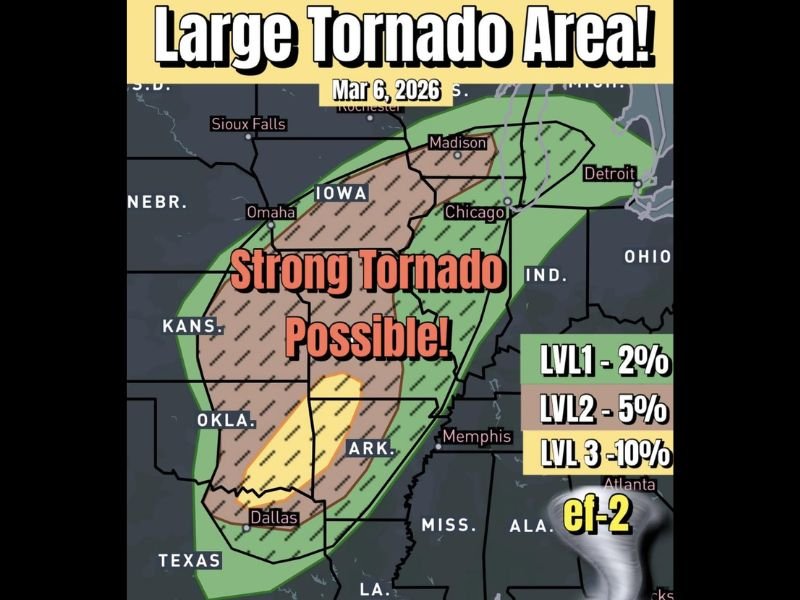
The severe weather zone stretches across a wide corridor including parts of Michigan, Illinois, Indiana, Iowa, Kansas, Arkansas, Oklahoma, and Texas, placing major cities such as Chicago, Detroit, Omaha, Memphis, and Dallas within the broader threat area.
Strong Tornado Potential Across Multiple States
Meteorologists say the atmospheric setup today includes strong wind shear and significant instability, two key ingredients that support tornado formation.
Forecast analysis highlights an especially concerning corridor stretching from Kansas through Iowa and into parts of southern Wisconsin and northern Illinois, where conditions may favor stronger storms capable of producing tornadoes. This region aligns closely with the Level 3 severe risk zone, which indicates an increased chance of organized severe storms capable of producing stronger tornadoes.
Secondary Tornado Target Near Central Kansas
Another area of concern is developing near a secondary low-pressure area in central Kansas, which could act as a focal point for storm initiation.
If storms are able to form along this boundary, they could rapidly intensify as they track northeast toward portions of Iowa and Illinois, increasing the risk of rotating thunderstorms. Forecasters say this area could become a “sneaky” severe weather hotspot if storm development begins along subtle atmospheric boundaries.
Damaging Winds and Large Hail Also Possible
In addition to tornadoes, storms developing across the region could produce very large hail and destructive straight-line winds.
Wind gusts exceeding 70 miles per hour are possible with stronger storm cells, which could lead to tree damage and localized power outages in some communities. Large hail may also accompany the strongest thunderstorms, particularly across areas where storms remain isolated and able to intensify rapidly.
Forecast Confidence Remains Uncertain
While the ingredients for severe weather appear strong, meteorologists caution that storm development itself remains somewhat uncertain. High-resolution weather models show fewer storms forming than expected, possibly due to a lack of strong large-scale forcing across the region.
However, experts note that even a small number of storms in this environment could become dangerous quickly if they develop along subtle atmospheric boundaries.
Monitoring Conditions Across the Midwest and Southern Plains
Weather agencies and meteorologists continue closely monitoring the evolving situation as the severe weather threat develops across the central United States.
Communities from Michigan and Illinois through Kansas, Arkansas, Oklahoma, and Texas are encouraged to stay alert for updated forecasts and potential severe weather warnings as storms begin to develop throughout the day.

I’ve lived in Naperville long enough to see how quickly our community changes — from new developments downtown to sudden shifts in our Midwest weather. Reporting on Naperville news and daily forecasts gives me the chance to keep neighbors informed about what really matters. My goal is simple: deliver clear, timely updates so you always know what’s happening in our city and what to expect from the skies above.