
Michigan Warms Into the 50s Across the South While Fog and Freezing Rain Threaten the Upper Peninsula on Sunday, February 15
Lansing, Michigan — Another warm February day is unfolding across the state on Sunday, February 15, 2026, as southern communities rise into the upper 40s and 50s, while northern Michigan remains cooler in the 30s. The day begins with patchy fog across several regions, transitioning to partly to mostly cloudy skies by afternoon. However, attention is turning to late-night freezing rain potential in the Upper Peninsula, which could create slick travel conditions heading into Monday.
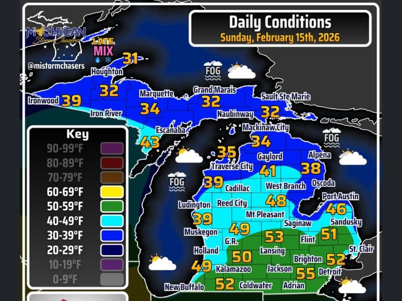
Temperature readings show a clear north-to-south divide. In the Upper Peninsula, Houghton sits at 31 degrees, Marquette at 34 degrees, and Grand Marais and Sault Ste. Marie both at 32 degrees. Ironwood is slightly warmer at 39 degrees, while Escanaba reaches 43 degrees, marking one of the warmer spots in the U.P.
Southern Michigan Enjoys Springlike 50s
Across the southern half of the state, a much warmer pattern is taking hold. Lansing climbs to 53 degrees, Detroit to 52 degrees, and Adrian leads the pack at 55 degrees. Flint (51 degrees), Brighton (52 degrees), and Jackson (50 degrees) are also experiencing well-above-average February temperatures.
Further west, Grand Rapids (49 degrees), Kalamazoo (52 degrees), and Holland (49 degrees) reflect steady warmth across West Michigan. The warming trend is partly attributed to increasing sun angle and a rapidly melting snowpack, which allows daytime temperatures to respond more efficiently to incoming solar energy.
Low wind speeds are helping maintain comfortable conditions despite lingering cloud cover. For many residents, the afternoon will feel more like early spring than mid-February.
Fog and Cloud Cover Start the Day
The morning begins with areas of fog, particularly near the Great Lakes shoreline and parts of northern Lower Michigan. Cities such as Traverse City (35 degrees) and Gaylord (41 degrees) are seeing cloudy skies with limited visibility early on.
Along Lake Huron, Alpena (38 degrees) and Oscoda remain under cloud cover, while Port Austin (46 degrees) edges closer to the warmer southern air mass. These mixed sky conditions are expected to gradually improve through the afternoon, though widespread sunshine is unlikely.
The fog is primarily driven by temperature contrasts between melting snow and mild air moving across colder ground surfaces.
Freezing Rain Risk Late Tonight in the Upper Peninsula
While most of Michigan will remain dry during the day, forecasters are monitoring freezing rain developing late tonight into Monday, particularly across the Upper Peninsula. As temperatures hover near or just below freezing in places like Houghton (31 degrees) and Marquette (34 degrees), any incoming moisture could freeze on contact.
This potential late-night mix may create hazardous travel conditions, especially on untreated roads and bridges. Residents in the U.P. are encouraged to stay alert for updated advisories as the system approaches.
Overall, Sunday brings a welcome break from harsh winter conditions across much of the state, but the temperature divide and overnight precipitation threat highlight Michigan’s ongoing seasonal transition. For continued regional weather coverage and updates that matter to Midwest readers, visit NapervilleLocal.com for daily reports and in-depth analysis.

I’ve lived in Naperville long enough to see how quickly our community changes — from new developments downtown to sudden shifts in our Midwest weather. Reporting on Naperville news and daily forecasts gives me the chance to keep neighbors informed about what really matters. My goal is simple: deliver clear, timely updates so you always know what’s happening in our city and what to expect from the skies above.