
Michigan Winter System Triggers “Rainbow Radar” Mix Near Gaylord as Snow, Rain and Ice Spread Across Traverse City, Petoskey and Sault Ste. Marie
MICHIGAN — A second winter system moving through northern Michigan is producing a messy, multi-type precipitation setup this morning, with radar showing a classic “Roy G. Biv” look as snow, rain, and mixed precipitation overlap across multiple communities in the Gaylord radar coverage area.
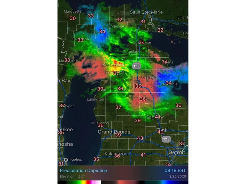
The radar snapshot labeled KAPX Gaylord shows several precipitation zones active as of 8:20 a.m., with temperatures hovering right around the freezing mark in several places—one of the biggest reasons precipitation type can change quickly from town to town. When temperatures are in the low 30s to upper 30s, even slight shifts in air temperature or intensity can flip conditions between wet snow, sleet, freezing rain, and plain rain.
Where the Wintry Mix Is Showing Up
Based on the locations visible on the radar image, the mixed precipitation zone stretches across a wide portion of northern Lower Michigan and into the eastern Upper Peninsula.
Communities shown within or near the active precipitation shield include:
- Traverse City (shown near 37°F)
- Petoskey (near 34°F)
- Cheboygan (near 34°F)
- Engadine (near 32°F)
- Sault Ste. Marie (near 31°F)
- Escanaba (near 33°F)
- Marquette (near 30°F)
- Ludington (near 39°F)
- Cadillac (near 36°F)
- Luzerne (near 35°F)
- Saginaw (near 41°F)
The temperature spread matters because areas closer to 31–32°F can support icing on bridges and untreated roads if freezing rain or sleet is occurring, while locations in the mid to upper 30s are more likely to see rain or wet snow with slushy accumulations.
What the “Roy G. Biv” Radar Look Usually Means
A radar appearance showing multiple colors and bands typically signals a changing precipitation structure, often caused by warm air wrapping into a winter system while colder air remains in place to the north or inland. In setups like this, roads can go from “just wet” to “slick” in minutes, especially on elevated surfaces.
The areas most vulnerable are typically:
- Locations sitting near 31–33°F
- Higher terrain and inland roads away from lake moderation
- Bridges, ramps, and untreated back roads
Even if most precipitation falls as rain in one community, a nearby town may be dealing with a glaze risk if temperatures are a degree or two colder.
Travel Concerns and What Residents Should Do
With precipitation types varying across short distances, the primary concern is travel. Drivers should expect inconsistent conditions, particularly where the mix line is active.
Smart precautions include:
- Slow down on highways and rural roads, especially near freezing temperatures
- Watch for slick spots on bridges and shaded roads
- Give plows and salt trucks extra space
- Keep extra stopping distance in case surfaces turn icy
This system is moving through now, and conditions may keep shifting through the morning as temperatures and precipitation intensity change. For more weather coverage written in a clear, community-focused format, visit NapervilleLocal.com for additional updates.

I’ve lived in Naperville long enough to see how quickly our community changes — from new developments downtown to sudden shifts in our Midwest weather. Reporting on Naperville news and daily forecasts gives me the chance to keep neighbors informed about what really matters. My goal is simple: deliver clear, timely updates so you always know what’s happening in our city and what to expect from the skies above.