
Michigan’s Lake Effect Snow Fades to a Narrow 1–3 Inch Band Near Munising While Most of the State Stays Largely Snow-Free
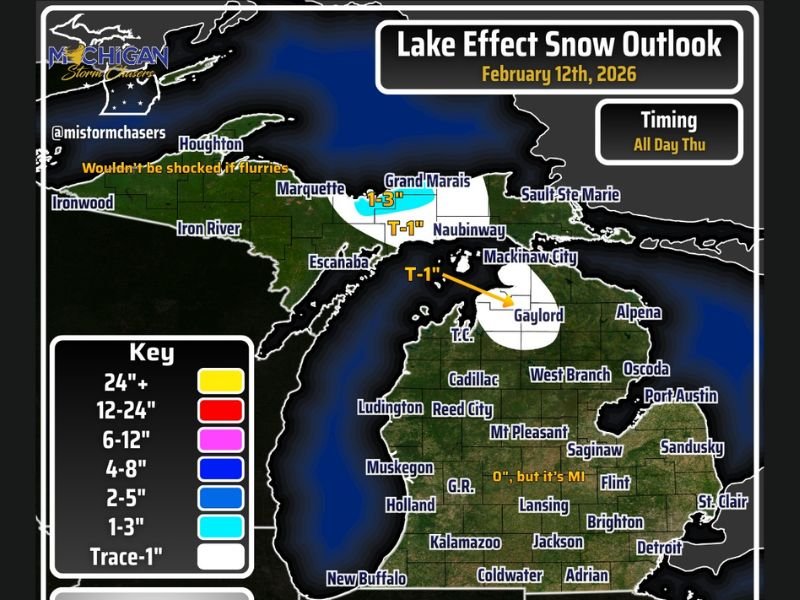
MICHIGAN — After weeks of persistent lake effect snow across parts of the state, February 12, 2026 is shaping up to be a much quieter winter day for most of Michigan. Forecast data shows only a narrow band of light lake effect snow, primarily focused near Munising in the Upper Peninsula, with much of the Lower Peninsula seeing little to no accumulation.
Just a few weeks ago, lake effect snow was an almost daily headline. Now, snowfall coverage has become far more limited, marking a noticeable shift in the winter pattern.
Light Band Targets Munising and Eastern Upper Peninsula
The primary area of concern today is near Munising and stretching toward Grand Marais in the eastern Upper Peninsula. Forecast projections indicate:
- 1 to 3 inches of snow possible near Munising
- Trace to 1 inch in nearby areas depending on band placement
While totals remain relatively light compared to earlier events this season, slick travel conditions could still develop — especially along stretches of M-28 near Munising.
Additional flurries may pop up elsewhere in the Upper Peninsula, including around Marquette, but accumulations outside the focused band are expected to remain minor.
Lower Peninsula Largely Snow-Free
Across the Lower Peninsula, snowfall chances are limited. Areas including Gaylord, Mackinaw City, and parts of northern Lower Michigan could see a trace to perhaps an inch if a secondary lake effect band briefly develops.
However, widespread accumulation is not expected. Farther south — including cities such as Grand Rapids, Lansing, Flint, Detroit, Kalamazoo, and Jackson — the outlook calls for little to no snowfall. Some light flurries are possible in isolated areas, but measurable snow is unlikely.
Petoskey Could See Minor Slick Spots
If a longer-lived lake effect band were to organize differently than currently projected, Petoskey could see minor accumulation. At this time, that scenario appears less likely, but drivers should remain alert for isolated slick patches — particularly in northern areas closer to Lake Michigan and Lake Superior influence zones.
A Reflective Moment in Michigan’s Winter
For many residents, today’s forecast serves as a reminder of how quickly winter patterns can shift. Earlier in the season, consistent lake effect events brought frequent snowfall headlines. Now, mid-February is trending comparatively quiet outside of a small Upper Peninsula corridor. While winter is far from officially over, today offers a relatively calm stretch for most of the state.
Drivers traveling through eastern Upper Michigan should plan for occasional reduced visibility and localized slick roads near Munising and along M-28. Elsewhere, conditions are expected to remain manageable. For continuing regional weather updates and detailed breakdowns of shifting winter patterns, stay connected with NapervilleLocal.com.

I’ve lived in Naperville long enough to see how quickly our community changes — from new developments downtown to sudden shifts in our Midwest weather. Reporting on Naperville news and daily forecasts gives me the chance to keep neighbors informed about what really matters. My goal is simple: deliver clear, timely updates so you always know what’s happening in our city and what to expect from the skies above.