
Midwest and East Could See a Mid-February “Big Thaw” With Several Days Above Freezing After Deep Arctic Cold, Forecast Graphic Shows
UNITED STATES — After weeks of deep Arctic air dominating large parts of the country, a forecast graphic shared with the provided data suggests a “big thaw” may arrive in mid-February, potentially delivering several days of above-freezing temperatures across a broad slice of the Midwest and Eastern United States.
The message at the top of the graphic notes that as the nation heads into next week, signs are pointing to a break from the cold, with a ridge setting up in the atmosphere. That ridging is linked to higher pressure aloft, which can translate into a warmer pattern at the surface. The post also emphasizes this does not mean winter is over—just that a significant warm-up window may be opening.
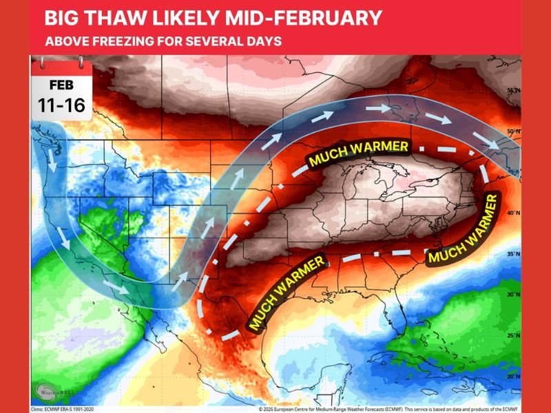
Timing window shown: Feb. 11–16
The graphic specifically highlights Feb. 11–16 as the period when the warm-up could take hold. During that stretch, the map shows a large area labeled “much warmer” arching from the central U.S. into the Midwest and East, signaling a shift in the overall jet stream configuration.
The accompanying note describes the expected warm-up as noticeable, especially compared to the Arctic conditions many regions have recently experienced.
What the pattern change is tied to
The explanation included with the data points to ridging in the jet stream. In simple terms, ridging often means the jet stream buckles northward, allowing warmer air to expand into areas that were previously locked in cold. When that ridge is strong enough, it can create a multi-day stretch where daytime highs climb above normal and overnight lows become less harsh.
The wording provided stresses that this isn’t a “winter is done” scenario—rather, it is a temporary break from the depths of the cold.
Where the “much warmer” zone is shown
The warmest anomaly shading and “much warmer” labeling stretches across a wide portion of the country, focused heavily on the central states, Midwest, and much of the East. The map presentation suggests that the warm-up isn’t confined to one state or one region, but could span multiple weather markets at the same time.
This is the kind of setup that can quickly flip impacts: areas that were dealing with ice, deep freezes, or persistent snowpack could shift into melting conditions, while places that were already mild could turn unusually warm for February.
What to watch during a thaw
A mid-winter thaw can bring its own set of issues even as it eases cold stress. Several days above freezing can lead to snowmelt, slush, and in some areas standing water, especially if a thaw overlaps with precipitation. If temperatures drop again afterward, refreezing can become a hazard.
For now, the takeaway from the provided data is the same as the headline on the graphic: a big thaw is possible, but it is still a winter pattern—and cold can return after the break.
Are you hoping for a thaw where you live, or are you worried about melt-and-refreeze problems? Share your thoughts and keep following NapervilleLocal.com for national weather pattern updates and what they could mean on the ground.

I’ve lived in Naperville long enough to see how quickly our community changes — from new developments downtown to sudden shifts in our Midwest weather. Reporting on Naperville news and daily forecasts gives me the chance to keep neighbors informed about what really matters. My goal is simple: deliver clear, timely updates so you always know what’s happening in our city and what to expect from the skies above.