
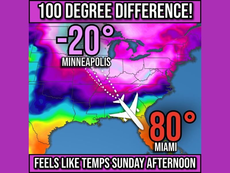
Midwest–Florida Temperature Divide to Hit 100 Degrees as Dangerous –20°F Cold Slams Minneapolis While Miami Reaches 80°F
UNITED STATES — A dramatic 100-degree temperature difference will stretch across the country this weekend as the Upper Midwest endures life-threatening cold while Florida basks in near-summer warmth. Forecast maps show Minneapolis plunging to –20°F with wind chills approaching –40°F, while Miami reaches a comfortable 80°F under sunny skies.
A Rare and Extreme Temperature Contrast Across the Nation
Meteorologists are highlighting the unusual split between two drastically different air masses dominating the continental U.S. On Sunday afternoon, feels-like temperatures in Minneapolis are expected to bottom out around –20°F, driven by arctic air spilling south from Canada. At the same time, a warm ridge over the Southeast will keep southern Florida in the upper 70s to low 80s, creating a coast-to-coast difference rarely seen outside of deep winter outbreaks.
The intensely cold air mass covering the Midwest will push across states including Minnesota, Wisconsin, Iowa, Illinois, and the Dakotas, with dangerous wind chills making outdoor conditions hazardous even for short durations. Meanwhile, the southeastern states will experience a mild, almost spring-like weekend, drawing thousands of seasonal travelers seeking warmth.
Upper Midwest Braces for Dangerous, Life-Threatening Cold
Cities including Minneapolis, Chicago, Milwaukee, and Des Moines will be under the influence of harsh arctic air, with Sunday morning wind chills plunging to –30°F to –40°F in parts of Minnesota and the Dakotas. These conditions pose heightened risks for frostbite, hypothermia, and infrastructure strain, especially during the early morning hours when temperatures will be lowest.
Even Chicago, which is more accustomed to winter extremes, is expected to endure dangerously low wind chills that could challenge residents and travelers across the region. Meteorologists warn that exposed skin may freeze in minutes, and vulnerable populations—including the elderly and the homeless—face increased risk.
The deep freeze will also impact transportation, with vehicles, rail systems, and air travel operations experiencing potential delays or mechanical complications due to the harsh temperatures.
Meanwhile, Miami and Florida Coast Enjoy Calm, Comfortable Warmth
In stark contrast, Miami will enjoy highs near 80°F, offering a far more pleasant weekend for residents and tourists. This warm pocket of air will stretch across much of southern and central Florida, making the state a favored destination for “snowbirds” escaping the brutal northern cold.
Travel demand into Florida is expected to rise, as social media trends already show people flocking to the Sunshine State for relief from winter weather gripping the Midwest. Beaches, parks, and outdoor events throughout South Florida are expected to see higher-than-normal attendance as locals and tourists take advantage of the unseasonably warm conditions.
What This Temperature Split Says About the Current Winter Pattern
While dramatic temperature contrasts are not unheard of in winter, a 100-degree difference between two major U.S. regions highlights the strength of the current polar jet stream pattern. A deep trough holding over the Midwest is forcing arctic air far south, while a strong ridge over the Southeast keeps Florida insulated from the cold.
Meteorologists note that such sharp temperature divides can impact storm development, travel patterns, and energy demand, with northern states likely to see temporary spikes in heating usage while Florida maintains typical mild-season activity.
As winter continues to unfold, stay connected to NapervilleLocal.com for updates on temperature extremes, storm developments, and nationwide weather trends impacting travel and daily life.

I’ve lived in Naperville long enough to see how quickly our community changes — from new developments downtown to sudden shifts in our Midwest weather. Reporting on Naperville news and daily forecasts gives me the chance to keep neighbors informed about what really matters. My goal is simple: deliver clear, timely updates so you always know what’s happening in our city and what to expect from the skies above.